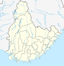
Sirdalsvatnet
Tools
Actions
General
Print/export
In other projects
Appearance
From Wikipedia, the free encyclopedia
Lake in Flekkefjord, Norway
| Sirdalsvatnet | |
|---|---|
| Location | Sirdal, Agder |
| Coordinates | 58°34′05″N 06°42′07″E / 58.56806°N 6.70194°E / 58.56806; 6.70194 |
| Primary inflows | Sira |
| Primary outflows | Sira |
| Catchment area | Sira river basin |
| Basin countries | Norway |
| Max. length | 27 kilometres (17 mi) |
| Max. width | 1 kilometre (0.62 mi) |
| Surface area | 18.8 km2 (7.3 sq mi) |
| Shore length1 | 59.91 kilometres (37.23 mi) |
| Surface elevation | 52 metres (171 ft) |
| References | NVE |
| 1 Shore length is not a well-defined measure. | |
Sirdalsvatnet is a lake in the municipalities of Sirdal and Flekkefjord in Agder county, Norway. The 18.8-square-kilometre (7.3 sq mi) lake is about 27 kilometres (17 mi) long running from the village of Tonstad in the north to the village of Sira in the south. The lake is about 1 kilometre (0.62 mi) wide at its widest point.[1]
See also
[edit]References
[edit]- ^ Store norske leksikon. "Sirdalsvatnet" (in Norwegian). Retrieved 2016-08-16.
Hidden categories:
- CS1 Norwegian-language sources (no)
- Articles with short description
- Short description matches Wikidata
- Pages using gadget WikiMiniAtlas
- Articles using infobox body of water without image
- Articles using infobox body of water without pushpin map alt
- Articles using infobox body of water without image bathymetry
- All stub articles


