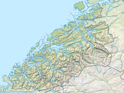
Eikesdalsvatnet
Appearance
| Eikesdalsvatnet | |
|---|---|
 View of the lake from the Goksøyra summit. | |
| Location | Molde Municipality, Møre og Romsdal, Norway |
| Coordinates | 62°32′35″N 08°10′13″E / 62.54306°N 8.17028°E |
| Primary inflows | Aura & Mardøla rivers |
| Primary outflows | River Eira |
| Basin countries | Norway |
| Max. length | 18 km (11 mi) |
| Max. width | 1.7 km (1.1 mi) |
| Surface area | 23.15 km2 (8.94 sq mi) |
| Max. depth | 155 m (509 ft) |
| Shore length1 | 44 km (27 mi) |
| Surface elevation | 22 m (72 ft) |
| Settlements | Eikesdalen |
| References | NVE |
| 1 Shore length is not a well-defined measure. | |
Eikesdalsvatnet is a lake in Molde Municipality in Møre og Romsdal county, Norway. The lake is long and narrow, roughly 18 kilometres (11 mi) in length, and it is the largest lake in Møre og Romsdal county. The village of Eikesdalen is located at the southern end of the lake.[1] Average depth is 89 meters (which is 67 meters below sea level) such that most of the lake's volume is below sea level.[2]
Its main inflows are the river Aura, flowing northwest from the lake Aursjøen, and the river Mardøla with the famous waterfall Mardalsfossen. The lake flows out through the River Eira which flows into the Eresfjorden. The lake is surrounded by 1,500-to-1,800-metre (4,900 to 5,900 ft) tall mountains like Juratinden and Fløtatinden.
See also
[edit]Wikimedia Commons has media related to Eikesdalsvatnet.
References
[edit]- ^ Store norske leksikon. "Eikesdalsvatnet" (in Norwegian). Retrieved 2010-10-31.
- ^ Dybdekart over Eikesdalsvatnet, NVE Dybdekartbok, Oslo, 1984.

