Portal:Mauritania
The Mauritania Portal - بوابة موريتانيا
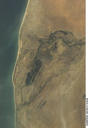
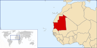
Mauritania, formally the Islamic Republic of Mauritania, is a sovereign country in Northwest Africa. It is bordered by the Atlantic Ocean to the west, Western Sahara to the north and northwest, Algeria to the northeast, Mali to the east and southeast, and Senegal to the southwest. By land area Mauritania is the 11th-largest country in Africa and 28th-largest in the world; 90% of its territory is in the Sahara. Most of its population of some 4.3 million lives in the temperate south of the country, with roughly a third concentrated in the capital and largest city, Nouakchott, on the Atlantic coast. The country's name derives from Mauretania, the Latin name for a region in the ancient Maghreb. It extended from central present-day Algeria to the Atlantic. Berbers occupied what is now Mauritania by beginning of the third century AD. Groups of Arab tribes migrated to this area in the late seventh century, bringing with them Islam, Arab culture, and the Arabic language. In the early 20th century, Mauritania was colonized by France as part of French West Africa. It achieved independence in 1960, but has since experienced recurrent coups and periods of military dictatorship. The 2008 Mauritanian coup d'état was led by General Mohamed Ould Abdel Aziz, who won subsequent presidential elections in 2009 and 2014. He was succeeded by General Mohamed Ould Ghazouani following the 2019 elections, head of an autocratic government with a very poor human rights record, particularly because of its perpetuation of slavery; the 2018 Global Slavery Index estimates there are about 90,000 slaves in the country (or 2.1% of the population).. Despite an abundance of natural resources, including iron ore and petroleum, Mauritania remains poor; its economy is based primarily on agriculture, livestock, and fishing. Mauritania is culturally and politically part of the Arab world; it is a member of the Arab League and Arabic is the official language. The official religion is Islam, and almost all inhabitants are Sunni Muslims. Despite its prevailing Arab identity, Mauritanian society is multiethnic; the Bidhan, or so-called "white moors", make up 30% of the population, while the Haratin, or so-called "black moors", comprise 40%. Both groups reflect a fusion of Arab-Berber ethnicity, language, and culture. The remaining 30% of the population comprises various sub-Saharan ethnic groups. (Full article...) Selected article - Located in the Sahelian and Saharan zones, Mauritania has one of the poorest agricultural bases in West Africa. Most important to the rural economy has been the livestock subsector. Between 1975 and 1980, herding engaged up to 70 percent of the population, and sedentary farmers constituted about 20 percent of the population. The vast majority of the population lived in the southern one-third of the country, where rainfall levels were high enough to sustain cattle herding. Farming was restricted to the narrow band along the Senegal River where rainfall of up to 600 millimeters per year and annual river flooding sustained crop production as well as large cattle herds. In the dry northern two-thirds of the country, herding was limited to widely scattered pastoral groups that raised camels, sheep, and goats, and farming was restricted to date palms and minuscule plots around oases. A major reason for Mauritania's economic stagnation since the mid-1970s has been the decline of its rural sector. Government planners neglected both herding and farming until the 1980s, concentrating instead on development in the modern sector. The rural sector was severely affected by droughts from 1968 through 1973 and from 1983 through 1985, and it has suffered from sporadic dry spells in other years. In the 1960s, livestock and crop production together provided 35 to 45 percent of GDP (at constant 1982 prices). From 1970 to 1986, their contribution to GDP (at constant 1982 prices) averaged 28 percent, with herding accounting for about 20 percent of this figure and with crop production falling to as low as 3 to 5 percent in the worst drought years. (Full article...) This is a Good article, an article that meets a core set of high editorial standards.
 Nouakchott (/nwækˈʃɒt, nwɑː-/ nwa(h)k-SHOT; French: [nwakʃɔt]; Arabic: نواكشوط, romanized: Nwākshūṭ, Hassaniyya: [nwakʃuːtˤ] ; Wolof: Nuwaaksoot; Pulaar: Nuwaasoot; Soninke: Nuwasooto; Berber: Nwakcoṭ, originally derived from Berber: Nawākšūṭ, 'place of the winds' or alternatively Zenaga: in wakchodh, 'having no ears') is the capital and largest city of Mauritania. Located in the southwestern part of the country, it is one of the largest cities in the Sahara. The city also serves as the administrative and economic center of Mauritania. Once a mid-sized coastal village, Nouakchott was selected as the capital for the nascent nation of Mauritania, with construction beginning in 1958. It was originally designed to accommodate a population of 15,000, but experienced significant population growth in the 1970s when many Mauritanians fled their home villages due to drought and increasing desertification. Many of the newcomers settled in slum areas of the city that were poorly maintained and extremely overcrowded. By the mid-1980s, Nouakchott's population was estimated to be between 400,000 to 500,000. (Full article...) CategoriesGeneral images -The following are images from various Mauritania-related articles on Wikipedia.
Related portalsWikiProjects
Topics in MauritaniaCities and towns
CommunesAssociated WikimediaThe following Wikimedia Foundation sister projects provide more on this subject:
Discover Wikipedia using portals | ||||||||||||||||||||||||||||||||||||||||||||||||||||||||||||||||


