Vũ Quang district
You can help expand this article with text translated from the corresponding article in Vietnamese. (July 2020) Click [show] for important translation instructions.
|
Vũ Quang district
Huyện Vũ Quang | |
|---|---|
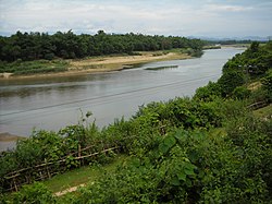
 Ngan Sau river, section passing Vu Quang, Ha Tinh | |
 | |
| Country | |
| Region | North Central Coast |
| Province | Hà Tĩnh |
| Capital | Vũ Quang |
| Area | |
• Total | 249 sq mi (646 km2) |
| Population (2003) | |
• Total | 32,242 |
| Time zone | UTC+7 (Indochina Time) |
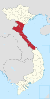
Vũ Quang is a rural district of Hà Tĩnh province in the North Central Coast region of Vietnam. As of 2003 the district had a population of 32,242.[1] The district covers an area of 646 km2 (249 sq mi). The district capital lies at Vũ Quang.[1]
Geography
[edit]Vũ Quang is an area of steep mountains and dense tropical forest in Hà Tĩnh province of Vietnam's North Central Coast. It is a very wet, hot area, whose mountains trap moisture coming in from the South China Sea. This creates a very stable but inhospitable climate. It rains continually in the rainy season, and in the dry season there is much fog; consequently most surfaces are algae-coated and slippery. The local hunters prefer to stay out of the forest, setting snares and using dogs to chase animals into more accessible areas.
History
[edit]Vũ Quang was used as a base by Phan Đình Phùng, the anti-colonial revolutionary, from 1885 to 1896.
See also
[edit]References
[edit]- ^ a b "Districts of Vietnam". Statoids. Retrieved March 20, 2009.

