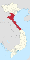
Quảng Ninh district
Appearance
You can help expand this article with text translated from the corresponding article in Vietnamese. (March 2009) Click [show] for important translation instructions.
|
Quảng Ninh District
Huyện Quảng Ninh | |
|---|---|
| Coordinates: 17°14′24″N 106°46′48″E / 17.24000°N 106.78000°E | |
| Country | |
| Region | North Central Coast |
| Province | Quảng Bình |
| Capital | Quảng Ninh |
| Area | |
• Total | 459.81 sq mi (1,190.89 km2) |
| Population (2003) | |
• Total | 90,000 |
| Time zone | UTC+7 (Indochina Time) |
Quảng Ninh is a rural district in Quảng Bình province. The district capital is Quán Hàu. Quảng Ninh borders Đồng Hới to the north, Bố Trạch to the northwest, Lệ Thủy district to the south and the South China Sea to the east. Quảng Ninh has an area of 1,190.89 km2, and in 2004 the population was 90,000. The district has 25 km of coastline and a 35 km border with Laos.[1] National Route 1, Ho Chi Minh Highway and the Hanoi–Saigon Railway crosses this district. The two main rivers are Nhật Lệ River and Long Đại River.
Subdivisions
[edit]This district is divided into:
- One townlet: Quán Hàu
- 14 communes (xã): Võ Ninh, Lương Ninh, Hải Ninh, Duy Ninh, Vĩnh Ninh, Hàm Ninh, Hiền Ninh, Xuân Ninh, An Ninh, Gia Ninh, Tân Ninh, Vạn Ninh, Trường Xuân and Trường Sơn.
References
[edit]- ^ "Huyện Quảng Ninh trên bước đường phát triển". quangbinh.gov.vn (in Vietnamese). Retrieved 2010-12-28.


