Talk:Goode homolosine projection
| This article is rated Start-class on Wikipedia's content assessment scale. It is of interest to the following WikiProjects: | |||||||||||
| |||||||||||
I've added some basic info about this projection, I'll be adding some more detail in the next couple of days. Such as uses for the projection, technical details (regions and lobes), examples. Also some links to producing these maps with raster and vector data.
Any specific information I should include?
--Ant 19:04, 22 September 2005 (UTC)
I seem to have ran out of time to work on this for now. --Ant 19:35, 30 September 2005 (UTC)
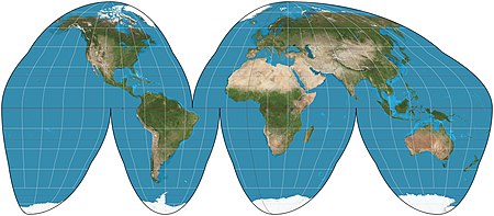
I've added a rendering of the projection. mdf 18:44, 26 October 2005 (UTC)
Unfortunately, none of the links work.
Yes, I also noticed they dont work. I am deleting them now. - MB 082508 —Preceding unsigned comment added by 81.226.201.82 (talk) 05:19, 25 August 2008 (UTC)
Ok, I deleted them, but they automatically revived again and I have no idea why. - MB 082508 —Preceding unsigned comment added by 81.226.201.82 (talk) 05:24, 25 August 2008 (UTC)
Replace low-contrast images
[edit]
I will be replacing images on the various map projection pages. Presently many are on a satellite composite image from NASA that, while realistic, poorly demonstrates the projections because of dark color and low contrast. I have created a stylization of the same data with much brighter water areas and a light graticule to contrast. See the thumbnail of the example from another article. Some images on some pages are acceptable but differ stylistically from most articles; I will replace these also.
The images will be high resolution and antialiased, with 15° graticules for world projections, red, translucent equator, red tropics, and blue polar circles.
Please discuss agreement or objections over here (not this page). I intend to start these replacements on 13 August. Thank you. Strebe (talk) 22:40, 6 August 2011 (UTC)
Tissot Indicatrices
[edit]This article would be improved with a second map showing the Tissot indicatrices of the map already present. F-Lambda (talk) 03:54, 7 February 2013 (UTC)
- Done. Strebe (talk) 09:24, 18 February 2013 (UTC)
File:Goode homolosine projection SW.jpg to appear as POTD
[edit]Hello! This is a note to let the editors of this article know that File:Goode homolosine projection SW.jpg will be appearing as picture of the day on February 26, 2015. You can view and edit the POTD blurb at Template:POTD/2015-02-26. If this article needs any attention or maintenance, it would be preferable if that could be done before its appearance on the Main Page. Thanks! — Crisco 1492 (talk) 23:29, 7 February 2015 (UTC)
- I edited the POTD blurb. The article itself seems reasonable enough for now. Thanks! Strebe (talk) 19:51, 21 February 2015 (UTC)


