Talk:Brown ocean effect
| This article is rated Start-class on Wikipedia's content assessment scale. It is of interest to the following WikiProjects: | ||||||||||||||
| ||||||||||||||
Wiki Education Foundation-supported course assignment
[edit]![]() This article is or was the subject of a Wiki Education Foundation-supported course assignment. Further details are available on the course page. Student editor(s): Sherwall15.
This article is or was the subject of a Wiki Education Foundation-supported course assignment. Further details are available on the course page. Student editor(s): Sherwall15.
Above undated message substituted from Template:Dashboard.wikiedu.org assignment by PrimeBOT (talk) 18:21, 17 January 2022 (UTC)
Globalize-section
[edit]My rationale for adding the maintenance tag is that the article's lead section reports that the effect is commonly observed over land in China and Australia. It would therefore make sense to include more examples from these tropical cyclones. 171.118.54.104 (talk) 17:22, 21 May 2017 (UTC)
- Best to make it not emphasize on "examples" with the intent of making each instance "notable". Focus more on generalization. KyuuA4 (Talk:キュウ) 21:18, 5 July 2017 (UTC)
Examples
[edit]The examples and perspective in this section may not represent a worldwide view of the subject. (May 2017) |

2001's Tropical Storm Allison spent a dozen days in June meandering slowly across the southeastern US from Texas to the Carolinas, generating torrential rains and looking much healthier over land than it would over the ocean prior to landfall and subsequent of departure.
Tropical Storm Erin of 2007 is an example of the effect, when the storm intensified over central Texas, eventually forming an eye over Oklahoma.[1][2][3] Tropical Storm Erin gained even more traction as it travelled across the plains, a rare feat as most tropical storms weaken as they go farther inland.[3] Anderson states "Until events like Erin in 2007, there was not much focus on post-landfall tropical cyclones unless they transitioned. Erin really brought attention to the inland intensification of tropical cyclones."[4]

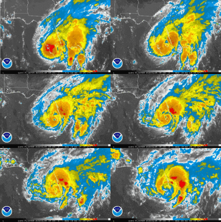
Tropical Storm Fay is an additional precedent for this type of phenomena, having attained a near-hurricane strength potency over central Florida; an intensity stronger than anything it had otherwise obtained over water.[5] While over land, the structure of the cyclone improved substantially, developing an eye-like characteristic.[6]
Another possible case is Tropical Storm Bill, when saturated soil conditions sustained the system for a longer period of time.[7]
Yet another example is Tropical Storm Julia, which intensified into a tropical storm while located over the U.S. state of Florida.[8]
Notes
[edit]Example list brought here for archiving. KyuuA4 (Talk:キュウ) 18:56, 17 July 2017 (UTC)
References
- ^ Cite error: The named reference
WUJun15was invoked but never defined (see the help page). - ^ "Sensitivity in the Overland Reintensification of Tropical Cyclone Erin (2007) to Near-Surface Soil Moisture Characteristics". 2011. Bibcode:2011MWRv..139.3848E. doi:10.1175/2011MWR3593.1.
{{cite journal}}: Cite journal requires|journal=(help); Unknown parameter|authors=ignored (help) - ^ a b "How 'Brown Oceans' Fuel Hurricanes". LiveScience.com. Retrieved 2016-03-01.
- ^ Cite error: The named reference
NASA2013was invoked but never defined (see the help page). - ^ Stewart/Beven (2009-02-08). "Tropical Cyclone Report: Tropical Storm Fay" (PDF). National Hurricane Center. Retrieved 2009-02-09.
- ^ Avila (2008-08-19). "Tropical Storm Fay Discussion Seventeen". National Hurricane Center. Retrieved 2008-08-19.
- ^ Bob Henson (22 June 2015). "Long-Lived Bill Meets its Demise in Mid-Atlantic".
- ^ Eric S. Blake (26 January 2017). "Tropical Cyclone Report: Tropical Storm Julia" (PDF). Miami, Florida: National Hurricane Center.
Hurricane Michael
[edit]Hurricane Michael was strengthening up until landfall with most of the storm over land in the pocket of Florida coast. B137 (talk) 04:33, 10 June 2020 (UTC)


