Six Rivers National Forest
| Six Rivers National Forest | |
|---|---|
 | |
Map of the United States | |
| Location | Northwest California, US |
| Nearest city | Crescent City, California |
| Coordinates | 41°46′40″N 124°01′00″W / 41.77778°N 124.01667°W |
| Area | 957,590 acres (3,875.2 km2) |
| Established | 1947 |
| Governing body | U.S. Forest Service |
| Website | Six Rivers National Forest |

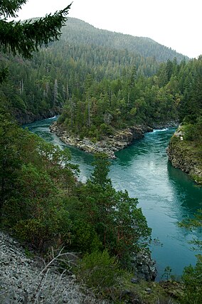
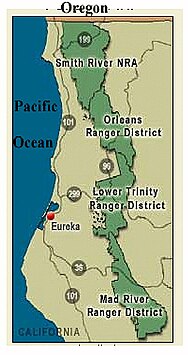
The Six Rivers National Forest is a U.S. National Forest located in the northwestern corner of California. It was established on June 3rd, 1947 by U.S. President Harry S. Truman from portions of Klamath, Siskiyou and Trinity National Forests. Its over one million acres (4,000 km2) of land contain a variety of ecosystems and 137,000 acres (550 km2) of old growth forest.[1] It lies in parts of four counties; in descending order of forestland area they are Del Norte, Humboldt, Trinity, and Siskiyou counties. The forest is named after the Eel, Van Duzen, Klamath, Trinity, Mad, and Smith rivers, which pass through or near the forest's boundaries.
The forest has 366 miles (589 km) of wild and scenic rivers, six distinct botanical areas, and public-use areas for camping, hiking, and fishing. The northernmost section of the forest is known as the Smith River National Recreation Area. Forest headquarters are located in Eureka, California. There are local ranger district offices in Bridgeville, Gasquet, Orleans, and Willow Creek.[2]
Its old-growth forests include Coast Douglas-fir (Pseudotsuga menziesii var. menziesii), Tanoak (Notholithocarpus densiflorus), Pacific madrone (Arbutus menziesii), and White Fir (Abies concolor).[1]
Wilderness areas
[edit]There are five designated wilderness areas in Six Rivers National Forest that are part of the National Wilderness Preservation System. Two of them lie mostly in other National Forests or on Bureau of Land Management land.
- Mount Lassic Wilderness
- North Fork Wilderness
- Siskiyou Wilderness (partly in Klamath NF)
- Trinity Alps Wilderness (mostly in Trinity NF; partly in Shasta NF, Klamath NF, or on BLM land)
- Yolla Bolly-Middle Eel Wilderness (mostly in Mendocino NF; partly in Trinity NF, or BLM land)
Important events
[edit]- The Patterson-Gimlin film, claimed to be a recording of a Bigfoot, was filmed in this national forest.
- Lyng v. Northwest Indian Cemetery Protective Association, a 1988 US Supreme Court decision, concerned land in the forest claimed as sacred by several local Native American tribes
- In 1947 Jose Garcia, father of a then present 5-year-old Jerry Garcia, slipped on a rock while fly fishing in the Trinity River and drowned. Jerry claimed to have witnessed this happen, though others familiar with the family assert that he did not.
See also
[edit]References
[edit]- ^ a b Warbington, Ralph; Beardsley, Debby (2002), 2002 Estimates of Old Growth Forests on the 18 National Forests of the Pacific Southwest Region, United States Forest Service, Pacific Southwest Region
- ^ USFS Ranger Districts by State
External links
[edit] Media related to Six Rivers National Forest at Wikimedia Commons
- Official website
- Six Rivers National Forest
- National forests of California
- Klamath Mountains
- Protected areas of Del Norte County, California
- Protected areas of Humboldt County, California
- Protected areas of Trinity County, California
- Protected areas of Siskiyou County, California
- 1947 establishments in California
- Protected areas established in 1947


