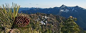
Siskiyou Wilderness
| Siskiyou Wilderness | |
|---|---|
 | |
| Location | Del Norte / Siskiyou / Humboldt counties, California, United States |
| Nearest city | Crescent City, California |
| Coordinates | 41°41′08″N 123°45′03″W / 41.68556°N 123.75083°W |
| Area | 182,802 acres (739.77 km2) |
| Established | 1984 |
| Governing body | U.S. Forest Service |
The Siskiyou Wilderness is a federal wilderness area designated by the passage of the California Wilderness Act of 1984. Originally, the land area was 153,000 acres (620 km2)[1] The Northern California Wild Heritage Act of 2006 added 30,122 acres (121.90 km2) for the current total of 182,802 acres (739.77 km2). All of the wilderness is in Northern California and is managed by the U.S. Forest Service. The wilderness spans three national forests: the Rogue River–Siskiyou, the Klamath, and the Six Rivers.
The Siskiyou Mountains form one of the longest continuous crests in the Klamath Mountains region. Elevations range from 770 feet (230 m) to the summit of Preston Peak at 7,309 feet (2,228 m) above sea level. Trending in a north–south direction from the Oregon border down to near the town of Weitchpec and 20 miles (32 km) inland from the Pacific Ocean, the Siskiyous are dotted by rocky peaks rising over 6,000 feet (1,800 m) from the surrounding lowlands.[2]
Flora and fauna
[edit]The Siskiyou Wilderness contains a diverse collection of conifer species including rarities such as Alaska cedar, Port Orford cedar, and the Klamath Mountains-endemic Brewer spruce.[3] It is notable for the vast amounts of old-growth forests and many endemic species of wildflowers, shrubs and trees, as well as one of the world's largest concentrations of lilies.[4]
The wilderness is home to several rare species, including wolverine, marten, fisher, northern spotted owl and Roosevelt elk. There is also black bear, black-tailed deer, and many varieties of birds. The clear streams provide spawning grounds for steelhead, coho and Chinook salmon.[5]

Recreation
[edit]The Clear Creek National Recreation Trail crosses 20.5 miles (33.0 km) of the northern portion and provides access to some of the more scenic parts of the wilderness—from near the Klamath River to the Smith River (California) divide. In the southern part of the wilderness, the Kelsey National Recreation Trail begins at Bear Lake, and the experienced hiker can walk for about 20 miles (32 km) to the Smith River. The most heavily visited areas are in the northwest corner of the region—concentrated on trails that lead to lakes. Much of the area lacks trails and is difficult to access cross-country because of the dense brush.[6] The Bigfoot Trail traverses the crest of the wilderness from north to south, through some of the most remote areas.
Climate
[edit]| Climate data for Siskiyou National Wilderness | |||||||||||||
|---|---|---|---|---|---|---|---|---|---|---|---|---|---|
| Month | Jan | Feb | Mar | Apr | May | Jun | Jul | Aug | Sep | Oct | Nov | Dec | Year |
| Record high °F (°C) | 69 (21) |
80 (27) |
92 (33) |
96 (36) |
108 (42) |
111 (44) |
115 (46) |
115 (46) |
110 (43) |
100 (38) |
82 (28) |
69 (21) |
115 (46) |
| Mean daily maximum °F (°C) | 50 (10) |
55 (13) |
61 (16) |
68 (20) |
76 (24) |
84 (29) |
92 (33) |
92 (33) |
86 (30) |
74 (23) |
57 (14) |
49 (9) |
70 (21) |
| Mean daily minimum °F (°C) | 31 (−1) |
33 (1) |
35 (2) |
37 (3) |
41 (5) |
47 (8) |
51 (11) |
51 (11) |
46 (8) |
39 (4) |
36 (2) |
31 (−1) |
40 (4) |
| Record low °F (°C) | 7 (−14) |
7 (−14) |
19 (−7) |
22 (−6) |
22 (−6) |
27 (−3) |
29 (−2) |
30 (−1) |
24 (−4) |
18 (−8) |
10 (−12) |
−2 (−19) |
−2 (−19) |
| Average precipitation inches (mm) | 9.16 (233) |
8.56 (217) |
6.90 (175) |
3.04 (77) |
1.55 (39) |
0.66 (17) |
0.31 (7.9) |
0.54 (14) |
1.24 (31) |
3.11 (79) |
7.86 (200) |
8.79 (223) |
51.72 (1,312.9) |
| Average snowfall inches (cm) | 3.40 (8.6) |
1.70 (4.3) |
0.60 (1.5) |
0.30 (0.76) |
0 (0) |
0 (0) |
0 (0) |
0 (0) |
0 (0) |
0 (0) |
0.90 (2.3) |
3.60 (9.1) |
10.50 (26.7) |
| Source: [7] | |||||||||||||
See also
[edit]Footnotes
[edit]- ^ "California Wilderness Act of 1984" (PDF). p. 5.
- ^ Adkinson 2001, p. 292.
- ^ Kauffmann, Michael (2012). Conifer Country. Kneeland: Backcountry Press. ISBN 978-0-578-09416-8.
- ^ Adkinson 2001, p. 294.
- ^ Adkinson 2001, p. 294-5.
- ^ "Siskiyou Wilderness". Wilderness.net. Retrieved 2007-12-21.
- ^ "Monthly data for Siskiyou Wilderness". The Weather Channel.
References
[edit]- Adkinson, Ron (2001). Wild Northern California. The Globe Pequot Press.
External links
[edit]- Siskiyou Wilderness: Six Rivers National Forest
- Siskiyou Wilderness: Rogue River–Siskiyou National Forest
- Siskiyou Wilderness: Klamath National Forest
- Preston Peak Botanical and Geological Area[permanent dead link]
- Hike Description to the Devil's Punchbowl
- IUCN Category Ib
- Klamath Mountains
- Rogue River-Siskiyou National Forest
- Protected areas of Del Norte County, California
- Protected areas of Humboldt County, California
- Protected areas of Siskiyou County, California
- Wilderness areas of California
- Klamath National Forest
- Six Rivers National Forest
- 1984 establishments in California
- Protected areas established in 1984

