Schmerling Caves
| Schmerling Caves | |
|---|---|
| Grottes d'Engis, Engis Caves | |
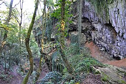
 Valley of the Awirs with the Schmerling Caves | |
| Location | Near Awirs and Engis, in Flémalle, Belgium |
| Coordinates | 50°35′32″N 5°24′32″E / 50.592222°N 5.408889°E |
| Length | 17 metres (56 ft), formerly at least 29 metres (95 ft); 5 metres (16 ft) wide |
| Height variation | 4–5 metres (13–16 ft), formerly at least 15 metres (49 ft) |
| Elevation | approx. 111 metres (364 ft) |
| Discovery | 1829 |
| Geology | Limestone |
| Entrances | At least three, but some collapsed |
| Hazards | Unstable; at least two chambers have collapsed |
| Access | Protected as a heritage site |
| Registry | Cultural Heritage of Wallonia (1979); Exceptional Cultural Heritage of Wallonia (2013) |
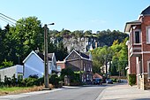
The Schmerling Caves (also known as Grottes d'Engis, meaning Engis Caves) are a group of caves located in Wallonia on the right bank of the stream called the Awirs, near the village of Awirs in Flémalle, Belgium. The caves are notable for their past fossil finds, particularly of hominins. They were explored in 1829 by Philippe-Charles Schmerling, who discovered, in the lower cave, the remains of two individuals, one of which, now known as Engis 2, was a fossil of the first Neanderthal ever found; the other was a Neolithic homo sapiens. Also known as Trô Cwaheur or Trou Caheur, this lower cave has since collapsed. A third cave was destroyed because of work on the adjacent quarry, the Ancienne Carrière des Awirs.
The caves have been classified on the list of Cultural Heritage of Wallonia sites since 1978,[1] as well as Exceptional Cultural Heritage of Wallonia since 2013,[2] because of the Neanderthal fossil.
Name, location, and finds
[edit]
Schmerling named the caves for Engis because he accessed them from the Plateau des Fagnes, which is in the Engis commune. He was able to reach them by lowering himself with a rope and sliding down the slope of the rock face. The caves themselves are actually within the boundaries of the commune of Awirs.[3] In 1951, a local group "corrected" the error by placing a plaque at the lower cave, identifying it as the Schmerling Cave.[4]
Schmerling thought he had found the remains of three people in the caves. In the vicinity, he also found tools fashioned by humans.[5] The tools and the carvings made with silex led him to argue that "antediluvian" man's hands must have been responsible even if human remains hadn't been found; Schmerling was thus one of the first to accept the existence of a prehistoric human. The child's skull was not identified as Neanderthal until 1936.[6]
A monument for Schmerling, consisting of a bust on a base made of stone, was erected at the foot of the hill in 1989; it was moved to the town square of Awirs in 2001.[4]
Description
[edit]Upper cave
[edit]
The measurements of the upper cave, which opens to the north, are 5m wide, 6m high, 17m deep,[clarification needed] with a small gallery on the right. At its entrance, in 2m of soil, Schmerling found:[7]
- a human incisor
- a human thoracic vertebrae
- a human phalanx bone
- remains of bears, hyena, horses, and ruminants
- silex tools.
Lower cave
[edit]
The lower cave was known as Trô Cwaheur.[4] It also opened to the north but has since been destroyed[8] following collapses in 1993 and 2006.[9] At the time of Schmerling's exploration, it measured 4 m wide by 5 m high. A first chamber was 12 m deep[clarification needed] and the cave continued beyond as a gallery with soil and bones. To the left of the entrance was another gallery with stalactites measuring 150cm long. Another gallery ascended into a second, smaller, chamber which was strewn with bones:[7]
- bones of bear, hyena, rhinoceros; some entire, some broken and showing evidence of having been moved by water
- a large human incisor
- an upper jaw bone with worn teeth
- two vertebrae
- a collarbone
- fragments of a radial bone and ulna
- a metacarpal bone and metatarsal bones
- next to animal remains, the skull of Neolithic homo sapiens, an older individual with the facial bones missing; designated Engis 1
- a second skull which fell to pieces when touched. Examination of the upper jaw revealed that adult molars had not yet descended: the individual was 5 or 6 years old at the time of death, and was designated Engis 2, following Schmerling. Milk teeth, collarbone, fragments of a radial bone, ulna, and vertebrae were found as well, leading the discoverer to think he had found the remains of three different individuals. The skull is registered as a national treasure on the List of Classified Properties of the French Community.
Other finds
[edit]
There was a third cave, to the east, which was destroyed in the exploitation of the quarry.[10] Later researchers who explored the hill found two more caves, one of them a grave site with two Neolithic skeletons.[8]
Grains of wheat were found in the Engis cave.[11]
See also
[edit]- Grotte de Rosée, a nearby cave
References
[edit]- ^ Direction générale opérationnelle de l'Aménagement du territoire, du Logement, du Patrimoine et de l'Énergie (DGO4) (2018). "Grottes Schmerling". Biens classés et Zones de protection. Service Public Wallonie (SPW). 62120-CLT-0006-01, DGO4: FLEMALLE/4. Archived from the original on 9 November 2018. Retrieved 8 November 2018 – via lampspw.wallonie.be DGO4 website archive.
{{cite web}}: CS1 maint: multiple names: authors list (link) CS1 maint: numeric names: authors list (link) - ^ DGO4 (2018). "Les grottes Schmerling". Biens exceptionnels. SPW. 62120-PEX-0001-02. Archived from the original on 9 November 2018. Retrieved 8 November 2018 – via lampspw.wallonie.be.
{{cite web}}: CS1 maint: numeric names: authors list (link) - ^ Biens classés et Zones de protection, Région wallonne, La biodiversité en Wallonie: Ancienne Carrière des Awirs
- ^ a b c "Les Chroniques" (PDF). Commission historique de la commune de Flémalle. April 2010. Retrieved 28 October 2018.
- ^ Winkler, T. C. (1877). "Vierde hoofdstuk". De mensch voor de geschiedenis (in Dutch). Leiden: P. van Santen. pp. 81–122.
- ^ Cliquet, Robert L.; Thienpont, Kristiaan (2002). Biologische variabiliteit bij de mens. Deel I. Determinanten en evolutie (in Dutch). Ghent: Academia Press. pp. 393–94. ISBN 9789038204307.
- ^ a b Philippe Charles Schmerling, Recherches sur les ossements fossiles découverts dans les cavernes de la province de Liège, Vol. I, Liège: P.-J. Collardin, 1833, pp. 30–31, 61, 62.
- ^ a b Engis et Néandertal Engis commune.
- ^ Les Awirs, la face nord
- ^ "...Les premières traces humaines...: La grotte de Schmerling" (in French). Archived from the original on 26 January 2013. Retrieved 28 October 2018.
- ^ Ernest Doudou, "Notes sur les grains de végétaux trouvés dans la brèche préhistorique de la Grotte d'Engis (Belgique)", Revue de l'École d'Anthropologie de Paris, January 1904, cited in: H. Desmaisons, "Blés et Céréales Préhistoriques", Bulletin de la Société préhistorique française, 32.6 1935, pp. 336–43.


