
Portal:New South Wales
The New South Wales Portal


New South Wales (commonly abbreviated as NSW) is a state on the east coast of Australia. It borders Queensland to the north, Victoria to the south, and South Australia to the west. Its coast borders the Coral and Tasman Seas to the east. The Australian Capital Territory and Jervis Bay Territory are enclaves within the state. New South Wales' state capital is Sydney, which is also Australia's most populous city. In December 2023[update], the population of New South Wales was over 8.3 million, making it Australia's most populous state. Almost two-thirds of the state's population, 5.3 million, live in the Greater Sydney area.
The Colony of New South Wales was founded as a British penal colony in 1788. It originally comprised more than half of the Australian mainland with its western boundary set at 129th meridian east in 1825. The colony then also included the island territories of Van Diemen's Land, Lord Howe Island, and Norfolk Island. During the 19th century, most of the colony's area was detached to form separate British colonies that eventually became the various states and territories of Australia and, arguably, New Zealand. The Swan River Colony (later called the Colony of Western Australia) was never administered as part of New South Wales. (Full article...)
 Recognized content -
-

Monaro Highway is a 285-kilometre-long (177 mi) highway in Victoria, New South Wales, and the Australian Capital Territory, in Australia, linking Cann River in Victoria to Canberra in the Australian Capital Territory (ACT) via the Monaro region. From its southern terminus, it follows the nearby Cann River upstream towards the New South Wales border through heavily forested terrain. Within New South Wales (NSW), it makes its way through further forest before reaching the pastures typical of the Monaro. There are multiple towns and villages along the highway, including Bombala, Nimmitabel and Cooma. The terrain within the Monaro is largely hilly, and there are numerous crossings. The road also parallels the former Bombala railway line in several locations. Within the ACT, the road becomes a high volume roadway and serves the southern suburbs of Canberra. The highway has more recently had a grade-separated dual carriageway extension constructed within Canberra, as part of the Eastern Parkway construction project. It is designated part of route M23, and route A23 within Canberra, and route B23 within Victoria and New South Wales, with a concurrency where it also carries route B72 between the two sections of Snowy Mountains Highway. (Full article...) -
Summer Hill is a suburb of Sydney, in the state of New South Wales, Australia. Summer Hill is located 7 kilometres west of the Sydney central business district, in the local government area of the Inner West Council.
Summer Hill is a primarily residential suburb of Sydney's Inner West, adjoining two of Sydney's major arterial roads, Parramatta Road and Liverpool Road. The first land grant was made in 1794 to former convict and jailor Henry Kable, and the suburb began growing following the opening of the railway station on the Main Suburban railway line, in 1879. (Full article...) -

Aleeta is a genus of cicadas with the only species Aleeta curvicosta (commonly known as the floury baker or floury miller, known until 2003 as Abricta curvicosta), one of Australia's most familiar insects. Native to the continent's eastern coastline, it was described in 1834 by Ernst Friedrich Germar.
The floury baker's distinctive appearance and loud call make it popular with children. Both the common and genus name are derived from the white, flour-like filaments covering the adult body. Its body and eyes are generally brown with pale patterns including a light-coloured line along the midline of the pronotum. Its forewings have distinctive dark brown patches at the base of two of their apical cells. The female is larger than the male, although species size overall varies geographically, with larger animals associated with regions of higher rainfall. The male has distinctive genitalia and a loud and complex call generated by the frequent buckling of ribbed tymbals and amplified by abdominal air sacs. (Full article...) -
The platypus (Ornithorhynchus anatinus), sometimes referred to as the duck-billed platypus, is a semiaquatic, egg-laying mammal endemic to eastern Australia, including Tasmania. The platypus is the sole living representative or monotypic taxon of its family Ornithorhynchidae and genus Ornithorhynchus, though a number of related species appear in the fossil record.
Together with the four species of echidna, it is one of the five extant species of monotremes, mammals that lay eggs instead of giving birth to live young. Like other monotremes, the platypus senses prey in cloudy water through electrolocation. It is one of the few species of venomous mammals, as the male platypus has a spur on the hind foot that delivers an extremely painful venom. (Full article...) -
From 31 May to 8 June 1942, during World War II, Imperial Japanese Navy submarines made a series of attacks on the Australian cities of Sydney and Newcastle. On the night of 31 May – 1 June, three Ko-hyoteki-class midget submarines, (M-14, M-21 and M-24) each with a two-member crew, entered Sydney Harbour, avoided the partially constructed Sydney Harbour anti-submarine boom net, and attempted to sink Allied warships. Two of the midget submarines were detected and attacked before they could engage any Allied vessels. The crew of M-14 scuttled their submarine, whilst M-21 was successfully attacked and sunk. The crew of M-21 killed themselves. These submarines were later recovered by the Allies. The third submarine attempted to torpedo the heavy cruiser USS Chicago, but instead sank the converted ferry HMAS Kuttabul, killing 21 sailors. This midget submarine's fate was unknown until 2006, when amateur scuba divers discovered the wreck off Sydney's northern beaches.
Immediately following the raid, the five Japanese fleet submarines that carried the midget submarines to Australia embarked on a campaign to disrupt merchant shipping in eastern Australian waters. Over the next month, the submarines attacked at least seven merchant vessels, sinking three ships and killing 50 sailors. During this period, between midnight and 02:30 on 8 June, two of the submarines bombarded the ports of Sydney and Newcastle. (Full article...) -
Edward Davis Millen (7 November 1860 – 14 September 1923) was an Australian journalist and politician who served as the first Minister for Repatriation.
Millen emigrated to Australia from England around 1880 and established himself as a journalist, subsequently serving in the New South Wales Legislative Assembly from 1894 to 1898, during which time he fiercely opposed the proposed Federation despite supporting the principle. He was a member of the New South Wales Legislative Council from 1899 until his election to the Australian Senate as a Free Trader from New South Wales at the first federal election in 1901. Millen led the conservative parties in the Senate from 1907 until shortly before his death in 1923. (Full article...) -

The Pacific blue-eye (Pseudomugil signifer) is a species of fish in the subfamily Pseudomugilinae native to eastern Australia. Described by Austrian naturalist Rudolf Kner in 1866, it comprises two subspecies that have been regarded as separate species in the past and may be once again with further study. It is a common fish of rivers and estuaries along the eastern seaboard from Cape York in North Queensland to southern New South Wales, the Burdekin Gap in central-north Queensland dividing the ranges of the two subspecies.
A small silvery fish averaging around 3.25 cm in total length (1+1⁄8–1+3⁄8 in), the Pacific blue-eye is recognisable by its blue eye-ring and two dorsal fins. It forms loose schools of tens to thousands of individuals. It eats water-borne insects as well as flying insects that land on the water's surface, foraging for them by sight. The Pacific blue-eye adapts readily to captivity. (Full article...) -
The 1994 FIFA World Cup CONCACAF–OFC qualification play-off was an association football match played over two legs between Australia and Canada. The first leg was played at Commonwealth Stadium in Edmonton, Canada, on 31 July 1993; the second leg was played on 15 August 1993 at Sydney Football Stadium in Sydney, Australia.
Both teams had played in their regional qualifiers to qualify for the play-off. The Canadians played in twelve matches in North American qualifying across two rounds. After finishing second in their second-round group to El Salvador, they qualified to the final round where they finished second by three points to Mexico. Australia played in six matches across two rounds in Oceania qualifying. After winning their group, they defeated New Zealand across two legs to make it to the play-off. (Full article...) -
Snowy Mountains Highway is a 333-kilometre-long (207 mi) state highway located in New South Wales, Australia. Its two sections connect the New South Wales South Coast to the Monaro region, and the Monaro to the South West Slopes via the Snowy Mountains. The higher altitude regions of this road are subject to snow over the winter months, and the road also provides access to many parts of the Snowy Mountains Scheme. The highway bears the B72 shield along its entire length.
The highway originally bore the name Monaro Highway until 1955, when it received its current name. It originally ran from Tathra to Wagga Wagga but has been shortened to run from Princes Highway to Hume Highway instead. Reservoirs created as a result of dams built in the 1950s and 1960s as part of the Snowy Mountains Scheme required the creation of major realignments to avoid submerged areas. Previous to New South Wales' conversion to alphanumeric route markers, it was signed as National Route 18. (Full article...) -
Abbotsford Bridge is a steel Allan truss-type road bridge that carries the Silver City Highway across the Murray River, between Curlwaa in New South Wales, and Yelta in Victoria, Australia. It is the only remaining steel truss bridge with a lift span that crosses the Murray. Opened in 1928, the bridge was built by the NSW Department of Public Works and was designed by Percy Allan. It was the second last vertical-lift bridge to be built over the river, the last being the Nyah Bridge, which opened in 1941.
The bridge was constructed over a three-year period from 1925. The project was not originally planned to take as long, but there were delays due to problems with a contractor, and industrial action. The bridge was designed to carry the Mildura railway line over the Murray River and into New South Wales, to service significant cross-border traffic arising from the fruit-growing industry, but the line was never extended beyond the terminus at Yelta. The bridge currently carries a single lane of road controlled by traffic lights. (Full article...) -
Maddison Gae Elliott, OAM (born 3 November 1998) is an Australian swimmer. At the 2012 Summer Paralympics in London, she became the youngest Australian Paralympic medallist by winning bronze medals in the women's 400 m and 100 m freestyle S8 events. She then became the youngest Australian gold medallist when she was a member of the women's 4 × 100 m freestyle relay 34 points team. At the 2016 Rio Paralympics, she won three gold and two silver medals. (Full article...) -
Isopogon anethifolius, commonly known as narrow-leaf drumsticks or narrow-leafed drumsticks, is a shrub in the family Proteaceae. The species is found only in coastal areas near Sydney in New South Wales, and to the immediate west. It occurs naturally in woodland, open forest and heathland on sandstone soils. An upright shrub, it can reach to 3 m (9.8 ft) in height, with terete leaves that are divided and narrow. The yellow flowers appear in the Spring, from September to December, and are prominently displayed. They are followed by round grey cones, which give the plant its common name of drumsticks. The small hairy seeds are found in the old flower parts.
Isopogon anethifolius regenerates after bushfire by resprouting from its woody base, known as a lignotuber, as well as from seed. It was described by Richard Salisbury in 1796, and was first grown in the United Kingdom the same year. One of the easiest members of the genus Isopogon to grow in cultivation, I. anethifolius grows readily in the garden if located in a sunny or part-shaded spot with sandy soil and good drainage. (Full article...) -
Ernest Raymond Herbert Toshack (8 December 1914 – 11 May 2003) was an Australian cricketer who played in 12 Tests from 1946 to 1948. A left arm medium paced bowler known for his accuracy and stamina in the application of leg theory, Toshack was a member of Don Bradman's "Invincibles" that toured England in 1948 without being defeated. Toshack reinforced the Australian new ball attack of Ray Lindwall and Keith Miller.
Born in 1914, Toshack overcame many obstacles to reach international level cricket. He was orphaned as an infant, and his early cricket career was hindered because of financial difficulties caused by the Great Depression. The Second World War prevented Toshack from competing at first-class level until he was into his thirties. In 1945–46, the first season of cricket after the end of the War, Toshack made his debut at first-class level and after only seven matches in the Sheffield Shield he was selected for Australia's tour of New Zealand. In Wellington, he opened the bowling in a match that was retrospectively classed as an official Test match. Toshack became a regular member of the Australian team, playing in all of its Tests until the 1947–48 series against India. He took his career-best match bowling figures of 11 wickets for 31 runs (11/31) in the First Test but began to suffer recurring knee injuries, and a medical board had to approve his selection for the 1948 England tour. Toshack played in the first four Tests before being injured. After a long convalescence, he attempted a comeback during Australia's 1949–50 season, but further injury forced him to retire. He was a parsimonious bowler, who was popular with crowds for his sense of humour. (Full article...) -

The Glasshouse arts and entertainment centre was central to the dismissal of Port Macquarie-Hastings Council
The dismissal of the Port Macquarie-Hastings Council on 27 February 2008 marked the end of a series of events involving a project which was initiated in 2001 in the New South Wales coastal town of Port Macquarie to build a cultural and entertainment centre, known to locals as the Glasshouse. The project, initially a joint venture with the management of the neighbouring shopping centre, Port Central, was originally expected to cost the Council A$7.3 million. However, by late 2007, despite the centre not yet having opened, the costs had blown out to over A$41.7 million, with interest repayments likely to extend the council's liability to A$66 million.
On 27 July 2007, a full public inquiry was announced by the Minister for Local Government, Paul Lynch. The inquiry reported its findings in February 2008. It found that the council had failed to provide appropriate financial and project management and had lost control of the costs, that the project costs had harmed the council's ability to provide services and amenities to the community, and that the council's communications management strategy had resulted in inadequate consultation with the public and inappropriate regard to their concerns. The Minister for Local Government dismissed the council and its mayor, Rob Drew, and appointed an administrator upon receiving the inquiry's report. Drew was critical of the process throughout, maintaining that errors had been made and misinformation had been accepted as fact; however, the New South Wales Urban Task Force, a property development lobby group, believed the sacking served as a warning to other councils to stick to "core responsibilities". (Full article...) -
The 1999 Sydney hailstorm was the costliest natural disaster in Australian insurance history, causing extensive damage along the east coast of New South Wales. The storm developed south of Sydney on the afternoon of Wednesday, 14 April 1999, and struck the city's eastern suburbs, including the central business district, later that evening.
The storm dropped an estimated 500,000 tonnes of hailstones in its path. The insured damage bill caused by the storm was over A$1.7 billion (equivalent to $3.8 billion in 2022), with the total bill (including uninsured damage) estimated to be around $2.3 billion. It was the costliest single natural disaster in Australian history in insured damage, surpassing the $1.1 billion in insured damage caused by the 1989 Newcastle earthquake. Lightning also claimed one life during the storm, and the event caused approximately 50 injuries. (Full article...)


_Scottsdale.jpg)

.jpg)


.jpg)


Selected image

Taronga Zoo is the zoological park of the city of Sydney. Founded in 1916, it is located on the shores of Sydney Harbour in Mosman. It is divided into eight zoogeographic regions and features over 2,600 animals on 28.7 hectares, making it one of the largest zoos of its kind.
Related portals

(Northern
Territory) |
WikiProjects
Selected articles -
-

Children outside some of the 27 houses at Boggabilla Station, November 1952.
Aboriginal reserves in New South Wales, together with Stations, and Aboriginal Missions in New South Wales were areas of land where many Aboriginal people were forced to live in accordance with laws and policies. The British government, which controlled the Australian colonies, and later the state governments had various policies of segregation and assimilation. The Aboriginal reserves were established by government authorities as portions of land set aside for the sole use of Aboriginal people, a practice that continued after Federation in 1901. Of the 85 Aboriginal reserves created from 1885 to 1895, 47 were initiated by Aboriginal families. The Register of Aboriginal Reserves 1875-1904 held by NSW State Archives includes a map of the locality and a description of the area and whether it is good for hunting and fishing.
The reserves were operated under the direction of various government authorities including the Aborigines Protection Board (1883–1940), the Aborigines Welfare Board (1940–1969) and the Aborigines Welfare Directorate (1969–1975). (Full article...) -

The South Wales Metro (Welsh: Metro De Cymru) is an integrated heavy rail, light rail and bus-based public transport services and systems network currently being developed in South East Wales around the hub of Cardiff Central railway station. The first phase was approved for development in October 2013. Works are currently under way, with a new depot under construction at Taff's Well and new trains being built by Stadler Rail in Switzerland. The development will also include the electrification of the core Valley Lines and new stations. All nine lines will be electrified, and the service is expected to be in operation by the end of 2024. (Full article...) -
Scone (/skoʊn/) is a town in the Upper Hunter Shire in the Hunter Region of New South Wales, Australia. At the 2021 census, Scone had a population of 5,013 people. It is on the New England Highway north of Muswellbrook about 270 kilometres(167.77 miles) north of Sydney, and is part of the New England (federal) and Upper Hunter (state) electorates. Scone is in a farming area and is also noted for breeding Thoroughbred racehorses. It is known as the 'Horse capital of Australia'. (Full article...) -
The Hawkesbury River, or Hawkesbury-Nepean River (Dharug: Dyarubbin) a river located northwest of Sydney, New South Wales, Australia. The Hawkesbury River and its associated main tributary, the Nepean River, almost encircle the metropolitan region of Sydney. The river between Wisemans Ferry and the Pacific Ocean marks the boundary of Greater Metropolitan Sydney in the south and the Central Coast region to the north.
The Hawkesbury River has its origin at the confluence of the Nepean River and the Grose River, to the north of Penrith and travels for approximately 120 kilometres (75 mi) in a north–easterly and then a south–easterly direction to its mouth at Broken Bay, about 15 kilometres (9.3 mi) from the Tasman Sea. The Hawkesbury River is the main tributary of Broken Bay. Secondary tributaries include Brisbane Water and Pittwater, which, together with the Hawkesbury River, flow into Broken Bay and thence into the Tasman Sea north of Barrenjoey Head. (Full article...) -
The New South Wales State Heritage Register, also known as NSW State Heritage Register, is a heritage list of places in the state of New South Wales, Australia, that are protected by New South Wales legislation, generally covered by the Heritage Act 1977 and its 2010 amendments. The register is administered by the Heritage Council of NSW via Heritage NSW, a division of the Government of New South Wales Department of Planning and Environment.
The register was created in 1999 and includes items protected by heritage schedules that relate to the State, and to regional and to local environmental plans. As a result, the register contains over 20,000 statutory-listed items in either public or private ownership of historical, cultural, and architectural value. Of those items listed, approximately 1,785 items are listed as significant items for the whole of New South Wales; with the remaining items of local or regional heritage value. The items include buildings, objects, monuments, Aboriginal places, gardens, bridges, landscapes, archaeological sites, shipwrecks, relics, bridges, streets, industrial structures and conservation precincts. (Full article...) -
The history of New South Wales refers to the history of the Australian state of New South Wales and the area's preceding Indigenous and British colonial societies. The Mungo Lake remains indicate occupation of parts of the New South Wales area by Indigenous Australians for at least 40,000 years. The British navigator James Cook became the first European to map the coast in 1770 and a First Fleet of British convicts followed to establish a penal colony at Sydney in 1788.
The colony established an autonomous parliamentary democracy from the 1850s and became a state of the Commonwealth of Australia in 1901 following a vote to federate with the other British colonies of Australia. Through the 20th century, the state was a major destination for an increasingly diverse collection of migrants from many nations. In the 21st century, the state is the most populous in Australia, and its capital, Sydney is a major financial capital and host to international cultural and economic events. (Full article...) -
Goulburn (/ˈɡoʊlbərn/ GOHL-bərn) is a regional city in the Southern Tablelands of New South Wales, Australia, approximately 195 kilometres (121 mi) south-west of Sydney and 90 kilometres (56 mi) north-east of Canberra. It was proclaimed as Australia's first inland city through letters patent by Queen Victoria in 1863. Goulburn had a population of 24,565 as of the 2021 census. Goulburn is the seat of Goulburn Mulwaree Council.
Goulburn is a railhead on the Main Southern line, and regional health & government services centre, supporting the surrounding pastoral industry as well as being a stopover for travellers on the Hume Highway. It has a central historic park and many historic and listed buildings. It is also home to the monument the Big Merino, a sculpture that is the world's largest concrete-constructed sheep. (Full article...) -
Geologically the Australian state of New South Wales consists of seven main regions: Lachlan Fold Belt, the Hunter-Bowen Orogeny or New England Orogen (NEO), the Delamerian Orogeny, the Clarence Moreton Basin, the Great Artesian Basin, the Sydney Basin, and the Murray Basin.
There are a few other sedimentary basins, the Great Artesian Basin can be broken into the Eromanga Basin in the west and the Surat Basin to the east. The Sydney Basin extends north into the Gunnedah Basin, which goes even further north into the Bowen Basin which extends into Queensland, under the Surat Basin. The New England Orogen has a few small Basins included, such as the Lorne Basin, the Myall Syncline, and Gloucester Basin. The Oaklands Basin is in the south of the state under the Murray Basin. The Darling Basin is in the state's west, but mostly covered by the Murray Basin. Gilgandra Sub-Basin and Paka Tank Trough are potential places for coal and gas. (Full article...) -
The Darling River (Paakantyi: Baaka or Barka) is the third-longest river in Australia, measuring 1,472 kilometres (915 mi) from its source in northern New South Wales to its confluence with the Murray River at Wentworth. Including its longest contiguous tributaries it is 2,844 km (1,767 mi) long, making it the longest river system in Australia. The Darling River is the outback's most famous waterway.
The Darling is in poor health, suffering from over-allocation of its waters to irrigation, pollution from pesticide runoff, and prolonged drought. During drought periods in 2019 it barely flowed at all. The river has a high salt content and declining water quality. Increased rainfall in its catchment in 2010 improved its flow, but the health of the river will depend on long-term management. (Full article...) -
Wodonga (pronounced /wəˈdɒŋɡə/; Pallanganmiddang: Wordonga) is a city on the Victorian side of the border with New South Wales, 324 kilometres (201 mi) north-east of Melbourne, Australia. It is part of the twin city of Albury-Wodonga and is located wholly within the boundaries of the City of Wodonga LGA and is separated from its twin city in New South Wales, Albury, by the Murray River. As of 2021 Wodonga and its suburbs have a population of 38,949 and combined with Albury, the two cities form the urban area Albury-Wodonga with a population of 97,793. There are multiple suburbs of Wodonga including Bandiana, Baranduda, Barnawartha, Bonegilla, Ebden, Huon Creek, Killara, Leneva and Staghorn.
Wodonga produces a gross domestic product of $2.5 billion per year on average. (Full article...) -
Sydney is the capital city of the state of New South Wales and the most populous city in Australia. Located on Australia's east coast, the metropolis surrounds Sydney Harbour and extends about 80 km (50 mi) from the Pacific Ocean in the east to the Blue Mountains in the west, and about 80 km (50 mi) from the Ku-ring-gai Chase National Park and the Hawkesbury River in the north and north-west, to the Royal National Park and Macarthur in the south and south-west. Greater Sydney consists of 658 suburbs, spread across 33 local government areas. Residents of the city are colloquially known as "Sydneysiders". The estimated population in June 2023 was 5,450,496, which is about 66% of the state's population. The city's nicknames include the "Emerald City" and the "Harbour City".
Aboriginal Australians have inhabited the Greater Sydney region for at least 30,000 years, and their engravings and cultural sites are common. The traditional custodians of the land on which modern Sydney stands are the clans of the Darug, Dharawal and Eora peoples. During his first Pacific voyage in 1770, James Cook charted the eastern coast of Australia, making landfall at Botany Bay. In 1788, the First Fleet of convicts, led by Arthur Phillip, founded Sydney as a British penal colony, the first European settlement in Australia. After World War II, Sydney experienced mass migration and by 2021 over 40 per cent of the population was born overseas. Foreign countries of birth with the greatest representation are mainland China, India, the United Kingdom, Vietnam and the Philippines. (Full article...) -
Nimbin is a town in the Northern Rivers area of the Australian state of New South Wales, approximately 30 km (19 mi) north of Lismore, 33 km (21 mi) northeast of Kyogle, and 70 km (43 mi) west of Byron Bay.
Nimbin is notable for the prominence of its environmental initiatives such as permaculture, sustainability, and self-sufficiency, as well as the cannabis counterculture. Writer Austin Pick described his initial impressions of the village this way: "It is as if a smoky avenue of Amsterdam has been placed in the middle of the mountains behind frontier-style building facades. ... Nimbin is a strange place indeed." (Full article...) -

New South Wales (in red)
New South Wales wine is Australian wine produced in New South Wales, Australia. New South Wales is Australia's most populous state and its wine consumption far outpaces the region's wine production. The Hunter Valley, located 130 km (81 mi) north of Sydney, is the most well-known wine region but the majority of the state's production takes place in the Big Rivers zone-Perricoota, Riverina and along the Darling and Murray Rivers. The wines produced from the Big Rivers zone are largely used in box wine and mass-produced wine brands such as Yellow Tail. A large variety of grapes are grown in New South Wales, including Cabernet Sauvignon, Chardonnay, Shiraz and Sémillon.
New South Wales is the second-largest wine-producing state in Australia, accounting for 30 percent of the A$5 billion Australian wine industry In 1994 the various wine regions within New South Wales agreed there was a need to form a peak lobby group to act as the conduit between industry and the New South Wales Government, and to represent New South Wales at the Federal level through the Winemakers Federation of Australia Inc. This body is the New South Wales Wine Industry Association. (Full article...) -
New England is a geographical region in the north of the state of New South Wales, Australia, about 60 km (37 mi) inland from the Tasman Sea. The area includes the Northern Tablelands (or New England Tablelands) and the North West Slopes regions. As of 2021, New England had a population of 185,560, with over a quarter of the people living in the area of Tamworth Regional Council. (Full article...) -
The Sydney Symphony Orchestra (SSO) is an Australian symphony orchestra based in Sydney. With roots going back to 1908, the orchestra was made a permanent professional orchestra on the formation of the Australian Broadcasting Commission in 1932. The orchestra has performed at the Sydney Opera House as its home concert hall, since the venue's opening in 1973. Simone Young is the orchestra's chief conductor and the first female conductor in the post. (Full article...)


.jpg)
_2019-06-21.jpg)


Did you know (auto-generated)

- ... that many an Xplorer has traversed the rails in Canberra?
- ... that in its two years of existence, the Hunter River Railway Company initiated construction on what would eventually become the Great Northern Railway connecting Sydney to Queensland?
- ... that Turkish international soccer player Rojin Polat was named member of the "2021 All Schools Merit Girls Team" in New South Wales, Australia?
General images -
-
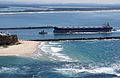 A bulk carrier entering the Port of Newcastle, New South Wales, 2009 (from Economy of New South Wales)
 -
 Governor Arthur Phillip hoists the British flag over the new colony at Sydney in 1788 (from History of New South Wales)
 -
 Landing of Lieutenant James Cook at Botany Bay, 29 April 1770, by E. Phillips Fox (from History of New South Wales)
 -
 World leaders with Prime Minister John Howard in Sydney for the 2007 APEC conference (from History of New South Wales)
 -
 Murray Grey cows and calves (from Economy of New South Wales)
 -
 Mr E.H. Hargraves, The Gold Discoverer of Australia, returning the salute of the gold miners - Thomas Tyrwhitt Balcombe, 1851 (from History of New South Wales)
 -
 Sydney Opera House was opened in 1973. (from History of New South Wales)
 -
 Olympic colours on the Sydney Harbour Bridge in the year 2000 (from History of New South Wales)
 -

-
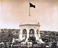 Federation Pavilion, Centennial Park, Sydney, 1 January 1901. (from History of New South Wales)
 -
 A 630 lb gold specimen from Hill End, unearthed in 1872 (from History of New South Wales)
 -
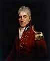 The 5th Governor of New South Wales, Lachlan Macquarie, was influential in establishing civil society in Australia (from History of New South Wales)
 -
 Hyde Park, Sydney with the Australian Museum under construction in the distance, 1842 (from History of New South Wales)
 -
 Aboriginal tribes in New South Wales, from an 1892 map (from History of New South Wales)
 -
 Bondi Beach circa 1900 (from History of New South Wales)
 -
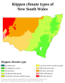 Köppen climate types in New South Wales (from Geography of New South Wales)
 -
 Ribbon ceremony to open the Sydney Harbour Bridge on 20 March 1932. Breaking protocol, the soon to be dismissed Premier Jack Lang cuts the ribbon while Governor Philip Game looks on. (from History of New South Wales)
 -

-
 Humanitarian Caroline Chisholm provided support to poverty-stricken women migrants (from History of New South Wales)
 -
 Tumut 3 Power Station was constructed as part of the vast Snowy Mountains Scheme in New South Wales (1949–1974). Construction necessitated the expansion of Australia's immigration program. (from History of New South Wales)
 -

-
 Dry paddocks in the Riverina region during the 2007 drought (from History of New South Wales)
 -
 Early expeditions of Charles Sturt (from History of New South Wales)
 -
 A General Chart of New Holland including New South Wales & Botany Bay with The Adjacent Countries and New Discovered Lands, published in An Historical Narrative of the Discovery of New Holland and New South Wales, London, Fielding and Stockdale, November 1786 (from History of New South Wales)
 -
 A chart of part of the interior of New South Wales by John Oxley, Surveyor General, 1822 (from History of New South Wales)
 -
 Founding of the settlement of Port Jackson at Botany Bay in New South Wales in 1788, by Thomas Gosse (from History of New South Wales)
 -
 William Wentworth was key in the establishment of self-governance in New South Wales (from History of New South Wales)


.jpg)


.jpg)


.jpg)
Topics
Categories

More portals
In the news
- 18 September 2024 –
- Alleged Ghost developer and administrator Jay Je Yoon Jung is arrested in Sydney, Australia, on five charges related to the encrypted communication network's development and operation. (The Register)
- 25 August 2024 –
- Four people are injured in a mass stabbing in Engadine, New South Wales, Australia. The suspect is later taken into custody. (Reuters)
Associated Wikimedia
The following Wikimedia Foundation sister projects provide more on this subject:
-
 Commons
Free media repository -
 Wikibooks
Free textbooks and manuals -
 Wikidata
Free knowledge base -
 Wikinews
Free-content news -
 Wikiquote
Collection of quotations -
 Wikisource
Free-content library -
 Wikiversity
Free learning tools -
 Wikivoyage
Free travel guide -
 Wiktionary
Dictionary and thesaurus


