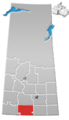
Mazenod, Saskatchewan
Mazenod | |
|---|---|
Unincorporated community | |
| Coordinates: 49°51′35″N 106°12′46″W / 49.85972°N 106.21278°W | |
| Country | Canada |
| Province | Saskatchewan |
| Rural Municipality | Sutton No. 103 |
| Government | |
| • Governing body | Rural Municipality of Sutton No. 103 |
| Area | |
• Total | 3.85 km2 (1.49 sq mi) |
| Population (2016) | |
• Total | 10 |
| • Density | 2.6/km2 (6.7/sq mi) |
| Time zone | CST |
| Area code | 306 |
| Highways | Highway 43 |
Mazenod (/ˈmeɪznɒd/, MAYZ-nod) is a hamlet in the Rural Municipality of Sutton No. 103, Saskatchewan, Canada. It is part of a region of wider French Catholic settlement centered around the town of Gravelbourg. The hamlet bears the name of Father Eugène de Mazenod, founder of the Missionary Oblates of Mary Immaculate, a religious order active in the settlement of Western Canada.
The hamlet is located 93 km southwest of the City of Moose Jaw on highway 43.
History
[edit]Prior to January 1, 2002, Mazenod was incorporated as a village, and was restructured as a hamlet under the jurisdiction of the R.M. of Sutton on that date.[1]
Demographics
[edit]In the 2021 Census of Population conducted by Statistics Canada, Mazenod had a population of 25 living in 11 of its 11 total private dwellings, a change of 150% from its 2016 population of 10. With a land area of 3.77 km2 (1.46 sq mi), it had a population density of 6.6/km2 (17.2/sq mi) in 2021.[2]
Notable people
[edit]See also
[edit]References
[edit]- ^ "Restructured Villages". Saskatchewan Ministry of Municipal Affairs. Archived from the original on March 25, 2008. Retrieved February 10, 2008.
- ^ "Population and dwelling counts: Canada and designated places". Statistics Canada. February 9, 2022. Retrieved August 31, 2022.


