Ferland, Saskatchewan
Appearance
Ferland | |
|---|---|
Unincorporated community | |
 Fransaskois flag flying outside church | |
| Coordinates: 49°27′00″N 106°57′04″W / 49.450°N 106.951°W | |
| Country | Canada |
| Province | Saskatchewan |
| Rural municipality | Mankota No. 45 |
| Time zone | CST |
| Area code | 306 |
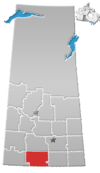
Ferland is a fransaskois hamlet in Mankota Rural Municipality No. 45, Saskatchewan, Canada. It previously held the status of village until November 4, 1988. The hamlet is located 10 km east of the Village of Mankota on highway 18.
Demographics
[edit]Prior to November 4, 1988, Ferland was incorporated as a village, and was restructured as a hamlet under the jurisdiction of the Rural municipality of Mankota on that date.[1]
In 2012, the government recognised the significant influence the francophone population had in Ferland's history, and so permanently installed a fransaskois flag in the hamlet.[2]
Infrastructure
[edit]See also
[edit]References
[edit]- ^ "Restructured Villages". Saskatchewan Ministry of Municipal Affairs. Archived from the original on March 25, 2008. Retrieved February 10, 2008.
- ^ "Bonjour SK - Flag". www.bonjoursk.ca. Retrieved June 12, 2018.


