Hibernia, New Jersey
Hibernia, New Jersey | |
|---|---|
 View along Green Pond Road | |
Location in Morris County Location in New Jersey | |
| Coordinates: 40°56′38″N 74°29′34″W / 40.94389°N 74.49278°W[1] | |
| Country | |
| State | |
| County | Morris |
| Township | Rockaway |
| Named for | Hibernia, the classical name for Ireland |
| Area | |
• Total | 2.26 sq mi (5.86 km2) |
| • Land | 2.16 sq mi (5.59 km2) |
| • Water | 0.10 sq mi (0.27 km2) |
| Elevation | 538 ft (164 m) |
| Population | |
• Total | 208 |
| • Density | 96.34/sq mi (37.19/km2) |
| ZIP Code | 07842 (Hibernia) 07866 (Rockaway) |
| FIPS code | 34-31170[4] |
| GNIS feature ID | 877076[1] |
Hibernia is an unincorporated community and census-designated place (CDP)[5] located along County Route 513 (Green Pond Road) in Rockaway Township of Morris County, in the U.S. state of New Jersey.[1][6] The area is served as United States Postal Service ZIP Code 07842. The community takes its name from Hibernia, the classical name for Ireland.[7]
As of the 2020 United States census, the area had a population of 208.[3]
The Hibernia mines, a series of iron mines worked from pre-Revolutionary times until 1916, are located here.
Geography
[edit]Hibernia is in northern Morris County, just south of the geographic center of Rockaway Township. It is bordered to the north by the community of Lake Telemark and to the south by the community of White Meadow Lake. County Route 513 (Green Pond Road) passes through Hibernia, leading north 6 miles (10 km) to Green Pond and 9 miles (14 km) to New Jersey Route 23 at Newfoundland, while to the south it leads less than 4 miles (6 km) to Rockaway borough.
The community sits at an elevation of 650 feet (198 m) in the valley of Hibernia Brook, between hills which rise to elevations over 1,000 feet (305 m) to the east and west. Hibernia Brook flows south toward Beaver Brook and is part of the Rockaway River watershed leading east to the Passaic River.
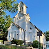
Since 1970, the former Methodist Episcopal Church on Green Pond Road has been used as a branch of the Rockaway Township Free Public Library.[8]
-
Methodist Episcopal Church, now a library
Demographics
[edit]| Census | Pop. | Note | %± |
|---|---|---|---|
| 2020 | 208 | — | |
| U.S. Decennial Census[9] | |||
Notable people
[edit]People who were born in, residents of, or otherwise closely associated with Hibernia include:
- Thomas J. Hillery (1871–1920), president of the New Jersey Senate[10]
References
[edit]- ^ a b c "Hibernia". Geographic Names Information System. United States Geological Survey, United States Department of the Interior. Retrieved September 24, 2012.
- ^ "2024 U.S. Gazetteer Files: New Jersey". United States Census Bureau. Retrieved October 14, 2024.
- ^ a b Census Data Explorer: Hibernia CDP, New Jersey, United States Census Bureau. Accessed June 15, 2023.
- ^ Geographic Codes Lookup for New Jersey, Missouri Census Data Center. Accessed June 9, 2023.
- ^ State of New Jersey Census Designated Places - BVP20 - Data as of January 1, 2020, United States Census Bureau. Accessed December 1, 2022.
- ^ "Locality Search". State of New Jersey.
- ^ Gannett, Henry (1905). The Origin of Certain Place Names in the United States. Govt. Print. Off. pp. 156.
- ^ "Library History". Rockaway Township Free Public Library.
- ^ "Census of Population and Housing". Census.gov. Retrieved June 4, 2016.
- ^ Biographical and Genealogical History of Morris and Sussex Counties, New Jersey. Vol. II. The Lewis Publishing Company. 1899. pp. 615–616 – via Google Books.
External links
[edit] Media related to Hibernia, New Jersey at Wikimedia Commons
- "Hibernia Historic District". The Historical Marker Database.
- Census 2000 Fact Sheet for ZIP Code Tabulation Area 07842 from the United States Census Bureau


