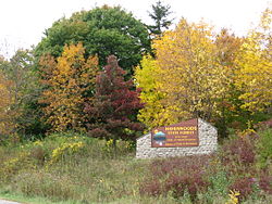
Havenwoods State Forest
Appearance
From Wikipedia, the free encyclopedia
State Forest in Milwaukee County, Wisconsin
| Havenwoods State Forest | |
|---|---|
IUCN category V (protected landscape/seascape) | |
 Pedestrian bridge in Havenwoods | |
| Location | Milwaukee, Wisconsin, United States |
| Coordinates | 43°7′43″N 87°58′13″W / 43.12861°N 87.97028°W / 43.12861; -87.97028 |
| Area | 237 acres (96 ha) |
| Established | 1979 |
| Governing body | Wisconsin Department of Natural Resources |
Havenwoods State Forest is a 237-acre (960,000 m2) property managed by the Wisconsin Department of Natural Resources within the city limits of Milwaukee. The forest was created to provide an urban green space and environmental education center.
The land includes grasslands, woods, wetlands, Lincoln Creek, an urban arboretum, and education gardens. The Environmental Awareness Center includes an auditorium, classrooms, displays, and a resource center. There are trails for nature study, hiking, biking, and cross-country skiing. Schoenecker Park abuts the property on the northeast.
Havenwoods is open from 6 a.m. to 8 p.m. daily. A state park vehicle admission sticker is not required to use the park.
References
[edit]External links
[edit]- Havenwoods State Forest official site
- Friends of Havenwoods


