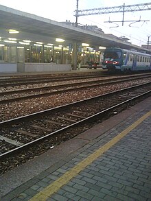
Gallarate railway station
 The station in 2008 | |||||
| General information | |||||
| Location | Piazza Giovanni XXIII Gallarate, Varese, Lombardy Italy | ||||
| Coordinates | 45°39′35.3″N 8°47′53.5″E / 45.659806°N 8.798194°E | ||||
| Elevation | 242 m (794 ft) | ||||
| Operated by | Rete Ferroviaria Italiana Centostazioni | ||||
| Line(s) | |||||
| Tracks | 8 | ||||
| Train operators | |||||
| Connections |
| ||||
| Other information | |||||
| Classification | Gold | ||||
| History | |||||
| Opened | 21 June 1873 | ||||
| Electrified | 14 October 1901 | ||||
| |||||
Gallarate railway station (Italian: Stazione di Gallarate) serves the town and comune of Gallarate, in the region of Lombardy, northern Italy. Opened in 1860, it is part of the Domodossola–Milan railway, and is a terminus of two secondary railways, Luino–Milan railway and Porto Ceresio–Milan railway.
The station is currently managed by Rete Ferroviaria Italiana (RFI). However, the commercial area of the passenger building is managed by Centostazioni. Each of these companies is a subsidiary of Ferrovie dello Stato (FS), Italy's state-owned rail company.
Train services are operated by Trenitalia, Trenord and TILO.
Location
[edit]Gallarate railway station is situated at Piazza Giovanni XXIII, on the southeastern edge of the city centre.
History
[edit]The station was opened on 20 December 1860, together with the Rho–Gallarate section of the Rho–Arona railway.[1]
On 24 July 1865, the next section of the Rho–Arona railway, from Gallarate to Sesto Calende, went into operation.[1] Two months later, on 26 September 1865, Gallarate became a junction station, for the newly opened Gallarate–Varese railway.[1]
On 17 March 1884, another secondary line, the Gallarate–Laveno railway, commenced operations into Gallarate.[1]
Features
[edit]The station yard has eight tracks, including five through tracks equipped with platforms:

- Track 1 is for direct trains to Domodossola, Geneva and Basel.
- Track 2 is for direct trains to Milano Centrale, Milano Porta Garibaldi coming from Domodossola/Luino.
- Track 3 is a through track used for terminating trains from Luino (via Gallarate–Laveno railway).
- Track 4 is a service track.
- Track 5 is used mainly by trains on line S5 of the Milan suburban railway network, and regional trains direct to Varese.
- Track 6 is used by trains on line S5 and regional trains from Varese.
- Tracks 7 and 8 are used by goods trains direct to Hupac's Busto Arsizio Terminal and to Switzerland via Luino or Domodossola.
Just beyond the station, towards Milan, is a goods yard, now abandoned, and a workshop for the maintenance of rolling stock. The workshop has been closed for over ten years, but may eventually reopen.
Adjacent to track 1 is a State Police station, close to the Commissariat.
Passenger and train movements
[edit]The station has about 6.6 million passenger movements each year.[2]
The passenger trains calling at the station are mainly regional services and Line S5 Milan suburban services. The station is also served by two pairs of EuroCity trains providing connections between Milan and either Geneva or Basel.
See also
[edit]References
[edit]- ^ a b c d Alessandro Tuzza; et al. "Prospetto cronologico dei tratti di ferrovia aperti all'esercizio dal 1839 al 31 dicembre 1926" [Chronological overview of the features of the railways opened between 1839 and 31 December 1926]. Trenidicarta.it (in Italian). Alessandro Tuzza. Archived from the original on 24 June 2009. Retrieved 7 January 2011.
- ^ "Flussi Annui nelle 103 Stazioni" [Annual flows at the 103 stations]. Centostazioni website (in Italian). Centostazioni. Archived from the original on 9 February 2010. Retrieved 4 December 2010.
External links
[edit]| Preceding station | Trenord | Following station | ||
|---|---|---|---|---|
| Sesto Calende towards Domodossola
|
RE4 | Busto Arsizio towards Milano Centrale
| ||
| Varese towards Porto Ceresio
|
RE5 | Busto Arsizio towards Milano Porta Garibaldi
| ||
| Besnate towards Luino
|
R21 | |||
| Cavaria-Oggiona-Jerago towards Varese
|
S5 | Legnano towards Treviglio
| ||
| Preceding station | Trenitalia | Following station | ||
| Casorate Sempione towards Domodossola
|
R23 | Busto Arsizio towards Milano Porta Garibaldi
| ||
| Preceding station | TILO | Following station | ||
| Besnate towards Cadenazzo
|
S30 | Terminus | ||
| Varese towards Airolo
|
S50 | Busto Arsizio towards Malpensa Aeroporto Terminal 2
| ||

