Cranleigh railway station
Cranleigh | |
|---|---|
 | |
| General information | |
| Location | Cranleigh, Waverley, Surrey England |
| Grid reference | TQ056391 |
| Platforms | 2 |
| Other information | |
| Status | Disused |
| History | |
| Pre-grouping | London, Brighton and South Coast Railway |
| Post-grouping | Southern Railway Southern Region of British Railways |
| Key dates | |
| 2 October 1865 | Opened as "Cranley" |
| 1867 | Renamed "Cranleigh" |
| 14 June 1965 | Closed |
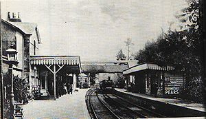
Cranleigh was a railway station on the Cranleigh Line between Guildford and Horsham. It served the village of Cranleigh, Surrey in southern England.
History
[edit]
Opening in 1865 as "Cranley", its name was changed in 1867 to "Cranleigh" at the request of the Postmaster General as imperfectly addressed letters to "Cranley" were often mistaken for "Crawley" and vice versa.[1]
A passing loop and second platform were installed at the station in 1880.[2] Cranleigh was the busiest station on the line with regular commuter traffic to and from London via Guildford. It also handled regular custom for nearby Cranleigh School,[3] and Southern Railway Class V 4-4-0 "Schools Class" express passenger locomotive no. 936 was named after the school in 1935.[4][5]
Cranleigh had a substantial goods yard equipped with a large loading gantry. Inward freight consisted mainly of coal which was required, in particular, by the local gasworks, whilst goods outward was mainly timber.[6][7]
The line was closed in 1965 following The Reshaping of British Railways report of 1963.[2] Cranleigh station was demolished shortly afterwards, replaced by the "Stocklund Square" housing and shopping development.[8] In 2004 part of this development was itself demolished and a Sainsbury supermarket was built on the site. The station's old platform levels still exist behind the shops. The station footbridge also survives,[9] in April 1967 it was re-erected at Liss railway station on the Portsmouth Direct Line.
| Preceding station | Disused railways | Following station | ||
|---|---|---|---|---|
| Bramley & Wonersh Line and station closed |
London, Brighton and South Coast Railway Horsham and Guildford Direct Railway |
Baynards Line and station closed |
Future
[edit]Studies of the feasibility of reopening the Guildford – Bramley – Cranleigh section of the line were completed in 1994, 1997 and 2009. The 1994 report concluded that the investment required would not justify reinstatement, but Waverley Borough Council has protected the line from development in its Local Plan. The 2009 report estimates that reopening the Guildford – Bramley – Cranleigh section would have a positive benefit-cost ratio of 1.7 to 1 including capital costs.[10]
Other Cranleigh Line stations
[edit]See also
[edit]References
[edit]- ^ Mitchell & Smith 1982, Fig. 15.
- ^ a b Jackson 1999, pp. 59–61.
- ^ Jackson 1999, pp. 140–141.
- ^ Swift 2006, pp. 81, 93.
- ^ Winkworth 1982, pp. 29–30.
- ^ Welch 2006, p. 41.
- ^ Jackson 1999, pp. 191–192.
- ^ Oppitz 1988, p. 81.
- ^ Weir, Luke (30 November 2021) [20 November 2021]. "The lost Surrey railway stations and what they are now amid Boris Johnson's HS2 changes". Surrey Live. Retrieved 6 April 2023.
- ^ Connecting Communities: Expanding Access to the Rail Network. London: Association of Train Operating Companies. June 2009. pp. 16, 18.
Sources
[edit]- Jackson, Alan A. (1999). The railway in Surrey. Penryn: Atlantic Transport. ISBN 0-90689-990-7.
- Oppitz, Leslie (1988). Surrey railways remembered. Reading: MRM. ISBN 1-85306-005-4.
- Mitchell, Vic; Smith, Keith (1982). Branch lines to Horsham. Midhurst: Middleton Press. ISBN 0-90652-002-9.
- Swift, Peter (2006). Maunsell 4-4-0 Schools Class. Locomotives in detail. Vol. 6. Hersham: Ian Allan. ISBN 0-71103-178-9.
- Welch, Michael (2006). Southern branch lines. Harrow: Capital Transport. ISBN 1-85414-306-9.
- Winkworth, D. W. (1982). The Schools 4-4-0s. Hemel Hempstead: George Allen & Unwin. ISBN 0-04385-095-2.

