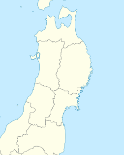
1804 Kisakata earthquake
Appearance
 | |
| Local date | July 10, 1804 |
|---|---|
| Magnitude | M7.0 |
| Epicenter | 39°03′N 139°57′E / 39.05°N 139.95°E[1] |
| Casualties | 300–500 fatalities |
The 1804 Kisakata earthquake (Japanese: 象潟地震) struck Dewa Province, Japan on July 10, 1804 with a magnitude of 7.0.[2][3][4] The earthquake killed approximately 300–500 people.[1][5] Nearby Mount Chokai erupted at about the same time as the earthquake.[6] Lake Kisakata was uplifted by the earthquake, so Kisakata, featured in Bashō's Oku no Hosomichi, became new land and a swamp.[2][4][7] A 1 m (3 ft 3 in) tsunami flooded 300 homes in Kisakata and Sakata.[8]
See also
[edit]References
[edit]- ^ a b 日本付近の主な被害地震 - Seismological Society of Japan
- ^ a b "象潟地震" (in Japanese). Kotobank. Retrieved 2023-04-07.
- ^ "象潟地震" (in Japanese). 災害カレンダー. Retrieved 2023-04-07.
- ^ a b "きさかたじしん【象潟地震】" (in Japanese). 学研キッズネット. Retrieved 2023-04-07.
- ^ 徳太郎, 羽鳥 (1986-08-04). "Investigations of the Seismic Intensity and Tsunami for the 1804 Kisakata Earthquake, the Japan Sea". 東京大學地震研究所彙報 = Bulletin of the Earthquake Research Institute, University of Tokyo (in Japanese). 61 (1): 143–157. doi:10.15083/0000032879.
- ^ "鳥海山 有史以降の火山活動". www.data.jma.go.jp. 気象庁. Retrieved 2023-04-07.
- ^ "象潟" (in Japanese). Kotobank. Retrieved 2023-04-07.
- ^ National Geophysical Data Center / World Data Service (NGDC/WDS) (1972), Global Historical Tsunami Database (Data Set), National Geophysical Data Center, NOAA, doi:10.7289/V5PN93H7, archived from the original on 2023-01-12, retrieved 2023-01-11

