Çumra
Çumra | |
|---|---|
District and municipality | |
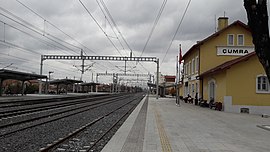
 Çumra railway station | |
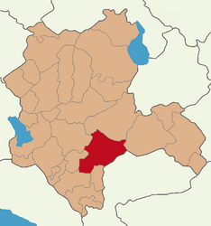
 Map showing Çumra District in Konya Province | |
| Coordinates: 37°34′30″N 32°46′29″E / 37.57500°N 32.77472°E | |
| Country | Turkey |
| Province | Konya |
| Government | |
| • Mayor | Mehmet Aydin (YRP) |
| Area | 2,089 km2 (807 sq mi) |
| Elevation | 1,020 m (3,350 ft) |
| Population (2022)[1] | 67,690 |
| • Density | 32/km2 (84/sq mi) |
| Time zone | UTC+3 (TRT) |
| Area code | 0332 |
| Climate | BSk |
| Website | www |
Çumra is a municipality and district of Konya Province, Turkey.[2] Its area is 2,089 km2,[3] and its population is 67,690 (2022).[1]
Geography
[edit]The town of Çumra is at an altitude of 1,020 m.[4] It is an important stop on the Istanbul to Baghdad railway. It is central to the 500 km²/120,000 acre Çumra irrigation zone, in the Konya Plain, that was established in 1912.[5]
Climate
[edit]Çumra's climate is classified as cold semi-arid (Köppen: BSk).[6] The town experiences hot, dry summers and chilly, frequently snowy winters.[7]
| Climate data for Çumra (1991–2020) | |||||||||||||
|---|---|---|---|---|---|---|---|---|---|---|---|---|---|
| Month | Jan | Feb | Mar | Apr | May | Jun | Jul | Aug | Sep | Oct | Nov | Dec | Year |
| Mean daily maximum °C (°F) | 5.4 (41.7) |
7.8 (46.0) |
13.3 (55.9) |
18.5 (65.3) |
23.5 (74.3) |
27.9 (82.2) |
31.2 (88.2) |
31.2 (88.2) |
27.3 (81.1) |
21.1 (70.0) |
13.5 (56.3) |
7.3 (45.1) |
19.1 (66.4) |
| Daily mean °C (°F) | 0.3 (32.5) |
1.8 (35.2) |
6.5 (43.7) |
11.4 (52.5) |
16.2 (61.2) |
20.3 (68.5) |
23.5 (74.3) |
23.2 (73.8) |
18.9 (66.0) |
13.2 (55.8) |
6.5 (43.7) |
2.1 (35.8) |
12.0 (53.6) |
| Mean daily minimum °C (°F) | −3.8 (25.2) |
−3.1 (26.4) |
0.4 (32.7) |
4.7 (40.5) |
9.0 (48.2) |
12.8 (55.0) |
15.5 (59.9) |
15.3 (59.5) |
10.9 (51.6) |
6.3 (43.3) |
0.9 (33.6) |
−1.9 (28.6) |
5.6 (42.1) |
| Average precipitation mm (inches) | 38.73 (1.52) |
26.29 (1.04) |
30.36 (1.20) |
35.69 (1.41) |
31.87 (1.25) |
24.34 (0.96) |
5.37 (0.21) |
3.43 (0.14) |
11.64 (0.46) |
24.12 (0.95) |
35.04 (1.38) |
48.67 (1.92) |
315.55 (12.42) |
| Average precipitation days (≥ 1.0 mm) | 6.0 | 5.1 | 5.3 | 5.5 | 5.4 | 4.0 | 1.6 | 1.6 | 2.6 | 4.4 | 4.4 | 7.1 | 53.0 |
| Average relative humidity (%) | 76.5 | 70.8 | 60.7 | 56.3 | 54.5 | 50.4 | 44.4 | 45.7 | 49.1 | 60.0 | 69.1 | 76.7 | 59.5 |
| Source: NOAA[8] | |||||||||||||
History
[edit]Neolithic (c. 8000 BC) archaeological discoveries have been found at Çatalhöyük.[9]
In the 12th century the Konya plain experienced its second great cultural period, when the city became the capital of the Seljuk Turks.[9]
Archaeological findings
[edit]In 2019, a farmer near the site of Türkmen-Karahöyük, a Bronze and Iron Age mounded settlement discovered a stone stele commissioned by Hartapu to commemorate his victory over Phrygia written in Luwian Hieroglyphics.[10] Archaeologists from the University of Chicago joined the Konya Regional Archaeological Survey Project to excavate the stele, and the excavations of the archaeological mound at the site, which is believed to be the capital of Hartapu's as yet unnamed kingdom, will continue in 2020.[11] In February 2020, archaeologists announced the discovery of Luwian hieroglyphs on the stone stele pulled out of the irrigation ditch next to the ancient mound of Türkmen-Karahöyük, describing the military victory of "Great King Hartapu" over an alliance of 13 kings.[12] The description has a reference to defeating the royal house of Phrygia, which included King Midas.[13]
Composition
[edit]There are 53 neighbourhoods in Çumra District:[14]
- Abditolu
- Adakale
- Afşar
- Alemdar
- Alibeyhüyüğü
- Alıssa
- Apa
- Apasaraycık
- Arıkören
- Avdul
- Bağlar
- Bakkalbaşı
- Balçıkhisar
- Baraj
- Bardakcı
- Beylerce
- Büyükaşlama
- Çaybaşı
- Çiçek
- Çukurkavak
- Cumhuriyet
- Dedemoğlu
- Dinek
- Dineksaray
- Dinlendik
- Doğanlı
- Erentepe
- Fethiye
- Gökhüyük
- Güvercinlik
- Hürriyet
- İçeriçumra
- İnli
- İstiklal
- İzzetbey
- Karkın
- Küçükköy
- Kuzucu
- Meydan
- Okçu
- Seçme
- Sürgüç
- Tahtalı
- Taşağıl
- Türkmencamili
- Türkmenkarahüyük
- Üçhüyük
- Ürünlü
- Uzunkuyu
- Yenidoğan
- Yenimahalle
- Yenisu
- Yörükcamili
Industry
[edit]Konya Şeker has a sugar factory with a small coal-fired autoproducer power plant, one of the Çoban Yıldızı power stations.
References
[edit]- ^ a b "Address-based population registration system (ADNKS) results dated 31 December 2022, Favorite Reports" (XLS). TÜİK. Retrieved 19 September 2023.
- ^ Büyükşehir İlçe Belediyesi, Turkey Civil Administration Departments Inventory. Retrieved 19 September 2023.
- ^ "İl ve İlçe Yüz ölçümleri". General Directorate of Mapping. Retrieved 19 September 2023.
- ^ Falling Rain Genomics, Inc. "Geographical information on Çumra, Turkey". Retrieved 25 September 2023.
- ^ PlanetWare.com - Çumra, Turkey
- ^ "Table 1 Overview of the Köppen-Geiger climate classes including the defining criteria". Nature: Scientific Data.
- ^ "Kar Örtülü Gün Sayısı" (PDF). MGM.
- ^ "World Meteorological Organization Climate Normals for 1991-2020 — Çumra". National Oceanic and Atmospheric Administration. Retrieved January 14, 2024.
- ^ a b Eskinazi.com - Central Anatolia
- ^ "Archaeologists Have Discovered a Lost Ancient Kingdom in Turkey". www.vice.com. Retrieved 2021-02-07.
- ^ "Oriental Institute archaeologists help discover lost kingdom in ancient Turkey". University of Chicago News. Retrieved 2021-02-07.
- ^ "Luwian Royal Inscription - Archaeology Magazine". www.archaeology.org. Retrieved 2021-02-07.
- ^ Dockrill, Peter. "Archaeologists in Turkey Have Discovered a Mysterious Ancient Kingdom Lost in History". ScienceAlert. Retrieved 2021-02-07.
- ^ Mahalle, Turkey Civil Administration Departments Inventory. Retrieved 19 September 2023.
External links
[edit]- District governor's official website (in Turkish)
- District municipality's official website (in Turkish)


