Sinop Province
Sinop Province
Sinop ili | |
|---|---|
 Sinop | |
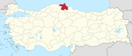
 Location of the province within Turkey | |
| Country | Turkey |
| Seat | Sinop |
| Government | |
| • Governor | Mustafa Özarslan |
Area | 5,717 km2 (2,207 sq mi) |
| Population (2022)[1] | 220,799 |
| • Density | 39/km2 (100/sq mi) |
| Time zone | UTC+3 (TRT) |
| Area code | 0368 |
| Website | www |
Sinop Province (Turkish: Sinop ili; Greek: Σινώπη, Sinopi) is a province of Turkey, along the Black Sea. It is located between 41 and 42 degrees North latitude and between 34 and 35 degrees East longitude. Its area is 5,717 km2, equivalent to 0.73% of Turkey's total area,[2] and its population is 220,799 (2022).[1] The borders total 475 km and consists of 300 km of land and 175 km seaside borders. Its adjacent provinces are Kastamonu on the west, Çorum on the south, and Samsun on the southeast.
The provincial capital is the city of Sinop.
Geography
[edit]Rivers
[edit]Kızılırmak, Gökırmak, Sarsak çay, Karasu, Ayancık Suyu, Tepeçay, Çakıroğlu, Kanlıdere[3]
Lakes
[edit]Sülüklü, Sarıkum
Bays
[edit]Districts
[edit]
Sinop province is divided into 9 districts (capital district in bold):
History
[edit]This section needs expansion. You can help by adding to it. (December 2021) |
It was part of Kastamonu Vilayet during the late Ottoman period.
References
[edit]- ^ a b "Address-based population registration system (ADNKS) results dated 31 December 2022, Favorite Reports" (XLS). TÜİK. Retrieved 19 September 2023.
- ^ "İl ve İlçe Yüz ölçümleri". General Directorate of Mapping. Retrieved 19 September 2023.
- ^ Sinop geography (tr) Archived 2012-05-10 at the Wayback Machine
External links
[edit]- Sinop governor's official website (in Turkish)
- Sinop municipality's official website (in Turkish)
- Sinop local news website Archived 2011-09-02 at the Wayback Machine (in Turkish)
42°00′N 35°00′E / 42.000°N 35.000°E


