Zarapicos
Appearance
Zarapicos | |
|---|---|
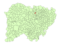
 Location in Salamanca | |
| Coordinates: 41°03′35″N 5°49′52″W / 41.05972°N 5.83111°W | |
| Country | Spain |
| Autonomous community | Castile and León |
| Province | Salamanca |
| Comarca | Tierra de Ledesma |
| Government | |
| • Mayor | Melquiades Pérez Sánchez (PSOE) |
| Area | |
| • Total | 7.65 km2 (2.95 sq mi) |
| Elevation | 784 m (2,572 ft) |
| Population (2018)[2] | |
| • Total | 59 |
| • Density | 7.7/km2 (20/sq mi) |
| Time zone | UTC+1 (CET) |
| • Summer (DST) | UTC+2 (CEST) |
| Postal code | 37170 |
Zarapicos (meaning Fox bites in English) is a municipality in the province of Salamanca, western Spain, part of the autonomous community of Castile-Leon. It is located 20 kilometers from the city of Salamanca and as of 2016 had a population only 55 people. The municipality covers an area of 8 km².[1]
The village lies 784 meters above sea level and the postal code is 37170.[1]
References
[edit]- ^ a b c "Municipio:Zarapicos". www.lasalina.es. Retrieved 2017-10-25.
- ^ Municipal Register of Spain 2018. National Statistics Institute.


