Herguijuela de la Sierra
Appearance
Herguijuela de la Sierra | |
|---|---|
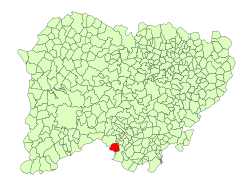
 Location in Salamanca | |
| Coordinates: 40°26′1″N 6°4′0″W / 40.43361°N 6.06667°W | |
| Country | Spain |
| Autonomous community | Castile and León |
| Province | Salamanca |
| Comarca | Sierra de Francia |
| Government | |
| • Mayor | Rafael Rivero Sánchez |
| Area | |
| • Total | 32 km2 (12 sq mi) |
| Elevation | 648 m (2,126 ft) |
| Population (2018)[2] | |
| • Total | 264 |
| • Density | 8.3/km2 (21/sq mi) |
| Time zone | UTC+1 (CET) |
| • Summer (DST) | UTC+2 (CEST) |
| Postal code | 37619 |
Herguijuela de la Sierra is a village and municipality in the province of Salamanca, western Spain, part of the autonomous community of Castilla y León. It is located 86 kilometres (53 mi) from the provincial capital city of Salamanca and has a population of 299 people. It is known, besides for its and other towns in the area's quaint old village air, for having a several-hundred-year-old beech tree nearby, one of two in all of western-central Spain.
Geography
[edit]The municipality covers an area of 32 square kilometres (12 sq mi). It lies 800 metres (2,600 ft) above sea level and the postal code is 37619. The Sierra de Francia Park is situated in the municipality.
References
[edit]- ^ a b "Municipio:Herguijuela de la Sierra". www.lasalina.es. Retrieved 2017-11-07.
- ^ Municipal Register of Spain 2018. National Statistics Institute.

