Wikipedia:Featured picture candidates/Fernão Vaz Dourado nautical chart
Appearance

- Reason
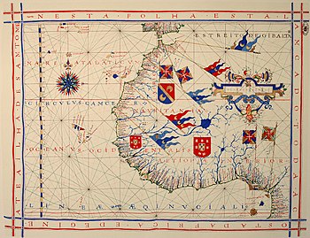
- A high quality reprodution of a gorgeous old nautical chart from one the best cartographers of the 16th century, a category which is very poorly illustrated in Wikipedia
- Articles this image appears in
- Fernão Vaz Dourado, Nautical chart, Cartography
- Creator
- Joaquim Alves Gaspar
- Support as nominator Alvesgaspar (talk) 10:31, 6 March 2008 (UTC)
- Support You don't see many old maps which aren't either mappa mundi or of Europe. At least I don't. Nice quality. faithless (speak) 11:28, 6 March 2008 (UTC)
- Support Shoemaker's Holiday (talk) 15:27, 6 March 2008 (UTC)
- Support--Mbz1 (talk) 13:59, 6 March 2008 (UTC)
- Support —αἰτίας •discussion• 18:19, 6 March 2008 (UTC)
- Support Important to both Portugese and African history, high quality file. DurovaCharge! 20:32, 6 March 2008 (UTC)
- Support per above. Juliancolton The storm still blows... 12:55, 7 March 2008 (UTC)
- Support. High quality and historical importance. - Darwinek (talk) 11:01, 8 March 2008 (UTC)
- Support Excellent! diego_pmc (talk) 15:35, 9 March 2008 (UTC)
- Support and comment. As a flag buff, I find myself wondering about the flags in this image. The Coat of arms of Portugal is pretty easy to pick out, and the gyronny-patterned (pinwheel) flags apparently denote city status in Portuguese heraldry (see Flag of Lisbon). But I don't recognize the gyronny flags with the knight's order crosses in them-- I wonder what they are (and I wonder what they're doing in West Africa). I also wonder about those crescent pennants-- do those represent one of the Barbary Coast states? Spikebrennan (talk) 14:38, 11 March 2008 (UTC)
- Sorry not to be able to satisfy your curiosity about the flags. What I know is that the cross inside those gyronny flags are of the Portuguese Order of Christ, the same that the ships used in the sails. As for the crescents, could it just represent the moor's (muslim) domination in the northern Africa?
Promoted Image:Fernão Vaz Dourado 1571-1.jpg MER-C 09:58, 13 March 2008 (UTC)
