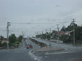
West Tamar Highway
Appearance
West Tamar Highway | |
|---|---|
 | |
 | |
| General information | |
| Type | Highway |
| Length | 65.2 km (41 mi) |
| Route number(s) | Launceston — Greens Beach |
| Former route number | |
| Major junctions | |
| South end | Launceston, Tasmania |
| |
| North end | Greens Beach Road Gardners Road Greens Beach, Tasmania |
| Location(s) | |
| Major settlements | Riverside, Legana, Exeter, Beaconsfield, Kelso |
| Highway system | |
The West Tamar Highway is a highway in Tasmania, Australia. It covers the western edge of the Tamar River, from Launceston to the beach town of Greens Beach.
It is labelled as state route A7.
Major intersections
[edit]Four shielded routes terminate at the intersections of streets in the Launceston CBD. Because all the involved streets are one-way each route has separate inbound and outbound termini.[2] One of these routes is the West Tamar Highway. Distances from each terminus to a point on the route may not be identical. Those shown below are from the outbound terminus.
| LGA | Location | km[3] | mi | Destinations | Notes |
|---|---|---|---|---|---|
| Launceston | Launceston | 0 | 0.0 | Southern end of West Tamar Highway. Road proceeds south west as York Street. | |
| South Esk River | 0.7– 0.8 | 0.43– 0.50 | The Paterson Bridge[4] | ||
| West Tamar | Riverside | 5.6 | 3.5 | Windsor Drive – northeast – Windsor Park Sports Complex | |
| Legana | 11.3 | 7.0 | |||
| 12.0– 12.1 | 7.5– 7.5 | Freshwater Point Road – northeast – Legana | |||
| 13.5 | 8.4 | ||||
| Lanena | 21.7 | 13.5 | |||
| Lanena, Blackwall, Exeter tripoint | 22.5 | 14.0 | |||
| Exeter | 23.8 | 14.8 | |||
| 23.9 | 14.9 | ||||
| Loira | 29.9 | 18.6 | |||
| Sidmouth | 33.1 | 20.6 | |||
| 34.8 | 21.6 | ||||
| Beaconsfield Flowery Gully midpoint | 38.5 | 23.9 | |||
| Beaconsfield | 41.4 | 25.7 | |||
| 42.0 | 26.1 | ||||
| 52.1 | 32.4 | West Tamar Highway turns from south west (out of Beauty Point) to north-west (towards Greens Beach) | |||
| York Town | 54.4 | 33.8 | |||
| Badger Head, Clarence Point midpoint | 55.3 | 34.4 | |||
| 55.4 | 34.4 | ||||
| Greens Beach | 65.1 | 40.5 | End of highway – road continues as Greens Beach Road | Northern end of West Tamar Highway | |
| 1.000 mi = 1.609 km; 1.000 km = 0.621 mi | |||||
See also
[edit]References
[edit]- ^ Former State Route Numbering System in Tasmania, Ozroads: the Australian Roads Website.
- ^ "Launceston CBD" (Map). Google Maps. Retrieved 30 October 2018.
- ^ "West Tamar Highway" (Map). Google Maps. Retrieved 1 November 2018.
- ^ "The Paterson Bridge". Stable Tasmanian Online Repository System (STORS). Libraries Tasmania. 2 November 1973. Retrieved 1 November 2018.
External links
[edit]![]() Media related to West Tamar Highway at Wikimedia Commons
Media related to West Tamar Highway at Wikimedia Commons
