Všestudy (Mělník District)
Appearance
Všestudy | |
|---|---|
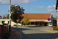
 Centre of Všestudy | |
| Coordinates: 50°17′27″N 14°20′34″E / 50.29083°N 14.34278°E | |
| Country | |
| Region | Central Bohemian |
| District | Mělník |
| First mentioned | 1295 |
| Area | |
| • Total | 4.72 km2 (1.82 sq mi) |
| Elevation | 170 m (560 ft) |
| Population (2024-01-01)[1] | |
| • Total | 432 |
| • Density | 92/km2 (240/sq mi) |
| Time zone | UTC+1 (CET) |
| • Summer (DST) | UTC+2 (CEST) |
| Postal codes | 277 44, 277 46 |
| Website | vsestudy-obec |
Všestudy is a municipality and village in Mělník District in the Central Bohemian Region of the Czech Republic. It has about 400 inhabitants.
Administrative parts
[edit]The village of Dušníky nad Vltavou is an administrative part of Všestudy.
Geography
[edit]Všestudy is located about 19 kilometres (12 mi) north of Prague. It lies in a flat agricultural landscape in the Central Elbe Table. The Vltava River briefly forms part of the municipal border in the north.
History
[edit]The first written mention of Všestudy is from 1295.[2]
Demographics
[edit]
|
|
| ||||||||||||||||||||||||||||||||||||||||||||||||||||||
| Source: Censuses[3][4] | ||||||||||||||||||||||||||||||||||||||||||||||||||||||||
Transport
[edit]The D8 motorway from Prague to Ústí nad Labem passes through the municipality.
Sights
[edit]There are no protected cultural monuments in the municipality.[5]
References
[edit]- ^ "Population of Municipalities – 1 January 2024". Czech Statistical Office. 2024-05-17.
- ^ "Základní informace" (in Czech). Obec Všestudy. Retrieved 2023-02-07.
- ^ "Historický lexikon obcí České republiky 1869–2011" (in Czech). Czech Statistical Office. 2015-12-21.
- ^ "Population Census 2021: Population by sex". Public Database. Czech Statistical Office. 2021-03-27.
- ^ "Výsledky vyhledávání: Kulturní památky, obec Všestudy". Ústřední seznam kulturních památek (in Czech). National Heritage Institute. Retrieved 2024-06-25.
External links
[edit]Wikimedia Commons has media related to Všestudy (Mělník District).


