User:Tanneneichhorn/Niederndorf (Freudenberg, Westphalia)
{{Infobox of a municipality in Germany | District of Niederndorf | Community type = City | Municipalities = Freudenberg (Siegerland) | Alternative ad-commune name = Freudenberg | Town coat | Latitude = 50/52 // N | Length of degree = 07/54 // E | State = North-Rhine / Westphalia | Height = 262 <!- Source: Geodata Center -> | Area = 6.82 | Population = 1741 | Inhabitants' stand-by date = 2011-12-31 | Date of incorporation = 1969-01-01 | Postcode1 = 57258 | Postal code2 = | Country code1 = 02734 | Dialing code2 = | Location map | Location map description }}
Freudenberg | |
|---|---|
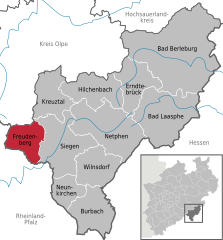
Location of Freudenberg within Siegen-Wittgenstein district  | |
| Coordinates: 50°53′59″N 07°52′00″E / 50.89972°N 7.86667°E | |
| Country | Germany |
| State | North Rhine-Westphalia |
| Admin. region | Arnsberg |
| District | Siegen-Wittgenstein |
| Subdivisions | 17 |
| Government | |
| • Mayor | Nicole Reschke (SPD) |
| Area | |
| • Total | 54.48 km2 (21.03 sq mi) |
| Elevation | 330 m (1,080 ft) |
| Population (2023-12-31)[1] | |
| • Total | 17,738 |
| • Density | 330/km2 (840/sq mi) |
| Time zone | UTC+01:00 (CET) |
| • Summer (DST) | UTC+02:00 (CEST) |
| Postal codes | 57258 |
| Dialling codes | 02734 |
| Vehicle registration | SI |
| Website | www.freudenberg-stadt.de |


Niederndorf 'is a district of Freudenberg in the Kreis Siegen-Wittgenstein, North Rhine-Westphalia.
geography
[edit]Niederndorf is located in the southern part of Freudenberg in a hilly middle mountain landscape and borders Rhineland-Palatinate (RLP). The neighborhoods are Oberfischbach, Dirlenbach and Niederfischbach (RLP). The highest peak in Niederndorf is the Giebelwald with . There also flows one of the brooks, which flow through the village, the Uebach. In the village, it flows into the Fischbach. The landscape around Freudenberg consists of about two-thirds of foliage and firs forests
History
[edit]Niederndorf was mentioned for the first time in the year 1423. <ref> Map Principality of Nassau-Siegen: Certificates of the settlement up to 1500 </ Ref>
In 1886 the road construction in Niederndorf led to a change in the townscape, when both the old mill and five houses had to give way. <Ref> Siegerländer Heimatkalender 1990, p.12, 65th edition, ed. Siegerländer Heimat- und Geschichtsverein eV , Verlag für Heimatliteratur </ ref> Niederndorf was incorporated into Freudenberg on 1 January 1969. <ref> [author missing] </ ref>
Population numbers
[edit]Population numbers of the place: <ref> Otto Schaefer: The circle Siegen , Siegen 1968 </ ref> <ref> freudenberg-stadt.de: MnavID = 1744.19 & sNavID = 1744.33 & La = 1 Population distribution (regularly updated) </ ref>
|
|
|
- ^ "Bevölkerung der Gemeinden Nordrhein-Westfalens am 31. Dezember 2023 – Fortschreibung des Bevölkerungsstandes auf Basis des Zensus vom 9. Mai 2011" (in German). Landesbetrieb Information und Technik NRW. Retrieved 2024-06-20.
- ^ Cite error: The named reference
administrative historywas invoked but never defined (see the help page).


