User:Iune/2009AHS
| Iune/2009AHS | |
|---|---|
 Season summary map | |
| Seasonal boundaries | |
| First system formed | May 28, 2009 |
| Last system dissipated | Still Active |
| Strongest storm | |
| Name | Bill |
| • Maximum winds | 135 mph (215 km/h) |
| • Lowest pressure | 943 mbar (hPa; 27.85 inHg) |
| Seasonal statistics | |
| Total depressions | 4 |
| Total storms | 3 |
| Hurricanes | 1 |
| Major hurricanes (Cat. 3+) | 1 |
| Total fatalities | 6 direct |
| Total damage | ~ $1.2 million (2009 USD) |
| Related article | |
The 2009 Atlantic hurricane season is an event in the annual cycle of tropical cyclone formation. The season officially started on June 1 and will end on November 30. These dates conventionally delimit the period of each year when most tropical cyclones form in the Atlantic basin.
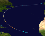
The season began early with the development of Tropical Depression One on May 28, but for the next two months the Atlantic basin went dormant. On August 15, both Tropical Storm Ana and Tropical Storm Bill developed in the relative vicinity of the Cape Verde Islands, marking the latest date since 1992 when a tropical cyclone was named in the Atlantic basin.[1] Claudette formed on August 16 and became the first storm of the season to make landfall in the United States early the next morning. Hurricane Bill became the first hurricane and first major hurricane of the season.
Seasonal forecasts
[edit]| Source | Date | Named storms |
Hurricanes | Major hurricanes | |
| Average (1950–2000) | 9.6 | 5.9 | 2.3 | ||
| Record high activity | 28 | 15 | 8 | ||
| Record low activity | 4 | 2 | 0† | ||
| ––––––––––––––––––––––––––––––––––––––––––––––––––––––– | |||||
| CSU | December 10, 2008 | 14 | 7 | 3 | |
| CSU | April 7, 2009 | 12 | 6 | 2 | |
| NOAA | May 21, 2009 | 9–14 | 4–7 | 1–3 | |
| CSU | June 2, 2009 | 11 | 5 | 2 | |
| UKMO | June 18, 2009 | 6* | N/A | N/A | |
| CSU | August 4, 2009 | 10 | 4 | 2 | |
| NOAA | August 6, 2009 | 7–11 | 3–6 | 1–2 | |
| –––––––––––––––––––––––––––––––––––––––––– | |||||
| Actual activity | 3 | 1 | 1 | ||
| * July-November only. † Most recent of several such occurrences. (See all) | |||||
Forecasts of hurricane activity are issued before each hurricane season by noted hurricane experts Philip J. Klotzbach, William M. Gray, and their associates at Colorado State University; and separately by NOAA forecasters.
Klotzbach's team (formerly led by Gray) defined the average number of storms per season (1950 to 2000) as 9.6 tropical storms, 5.9 hurricanes, 2.3 major hurricanes (storms reaching at least Category 3 strength in the Saffir-Simpson Hurricane Scale) and ACE Index 96.1.[2] NOAA defines a season as above-normal, near-normal or below-normal by a combination of the number of named storms, the number reaching hurricane strength, the number reaching major hurricane strength and ACE Index.[3]
Pre-season forecasts
[edit]On December 10, 2008, Klotzbach's team issued its first extended-range forecast for the 2009 season, predicting above-average activity (14 named storms, 7 hurricanes, 3 of Category 3 or higher and ACE Index of 125). On April 7, 2009, Klotzbach's team issued an updated forecast for the 2009 season, predicting near-average activity (12 named storms, 6 hurricanes, 2 of Category 3 or higher and ACE Index of 100), citing the possible cause as the high probability of a weak El Niño forming during the season.[4] On May 21, 2009, NOAA issued their forecast for the season, predicting near or slightly above average activity, (9 to 14 named storms, 4 to 7 hurricanes, and 1 to 3 of Category 3 or higher).[5]
Midseason outlooks
[edit]On June 2, 2009, Klotzbach's team issued another updated forecast for the 2009 season, predicting slightly below average activity (11 named storms, 5 hurricanes, 2 of Category 3 or higher and ACE Index of 85). On June 18, 2009, the UK Met Office (UKMO) issued a forecast of 6 tropical storms in the July to November period with a 70% chance that the number would be in the range 3 to 9. They also predicted an ACE Index of 60 with a 70% chance that the index would be in the range 40 to 80.[6] On August 4, 2009, Klotzbach's team updated their forcast for the 2009 season, again predicting slightly below average activity (10 named storms, 4 hurricanes, and 2 major hurricanes). On August 6, 2009, the NOAA also updated their forecast for the 2009 season, predicting below average activity (7-11 named storms, 3-6 hurricanes, and 1-2 major hurricanes).
Storms
[edit]Tropical Depression One
[edit]| Tropical depression (SSHWS) | |
| Duration | May 28 – May 29 |
|---|---|
| Peak intensity | 35 mph (55 km/h) (1-min); 1006 mbar (hPa) |
On May 28, the National Hurricane Center began issuing advisories on Tropical Depression One. The depression had formed about 400 miles (640 km) east-northeast of the Outer Banks of North Carolina. With relatively favorable conditions, the depression was forecast to strengthen into a tropical storm by early May 29 before dissipating over cooler waters shortly thereafter. However, the system did not reach tropical storm strength, and instead began to rapidly weaken later on the 29th.[7] The depression became extratropical at about 5 p.m. AST (2100 UTC) that same day,[8] and was absorbed by a frontal zone shortly thereafter.
Tropical Storm Ana
[edit]| Tropical storm (SSHWS) | |
| Duration | August 11 – August 17 |
|---|---|
| Peak intensity | 40 mph (65 km/h) (1-min); 1004 mbar (hPa) |
On August 11, Tropical Depression Two developed west of the Cape Verde Islands and was quickly forecasted to become a tropical storm. On August 13, however, exposure to upper level wind shear and dry air led to the storm degenerating into a remnant low. Still, the storm was forecasted to strengthen back into a depression.[9] The system's remnants did in fact regenerate into a tropical depression shortly after midnight. Just hours later the depression was upgraded into Tropical Storm Ana and tropical storm watches were issued for most of the Leeward Islands.[10] On August 16, Ana degenerated into a Tropical Depression again after an Air Force hurricane hunter aircraft found the storm to be very poorly organized and even further dissipation was predicted.[11] Overnight, Ana moved across the Leeward Islands with little change in intensity predicted. The storm was forecasted to track across the northeastern Caribbean Sea and approach Hispaniola by August 17. Dry air and moderate shear took their toll on Ana, and it dissipated over the northern Caribbean that day. Tropical Storm Ana was one of three tropical storms active on August 16.
Hurricane Bill
[edit]| Category 4 hurricane (SSHWS) | |
| Duration | August 15 – August 24 |
|---|---|
| Peak intensity | 135 mph (215 km/h) (1-min); 943 mbar (hPa) |
Late on August 12, a strong tropical wave associated with an area of low pressure moved off the African coast with deep layers of moisture observed.[12] Later that day, the wave became better organized with a low level circulation forming, but without any significant convection. That night, the area of convection became more concentrated, but wind shear increased since the previous advisory. On August 14, the disturbance strengthened more and its convective bands became stronger with better circulation, indicating that the disturbance would soon become a tropical depression. Later, on August 15, even though some of its deep convection dissipated, it was officially named Bill, the second named storm of the 2009 season. Early on August 17, an eye appeared on visible and infrared loops and Bill strengthened into a hurricane, the first of the 2009 season. Bill then briefly underwent an eyewall replacement cycle, as the eye had contracted to a half its original size. However, strengthening continued and, on the evening of August 18, Bill rapidly strengthened into a major hurricane. Tropical Storm Bill was one of three tropical storms active on August 16. It lost tropical characteristics after making landfall on Newfoundland as a weakening Category 1 hurricane on August 24.
Tropical Storm Claudette
[edit]| Tropical storm (SSHWS) | |
| Duration | August 16 – August 18 |
|---|---|
| Peak intensity | 50 mph (85 km/h) (1-min); 1006 mbar (hPa) |
Tropical Storm Claudette formed as the fourth depression of the season in the eastern Gulf of Mexico on August 16. The disturbance developed rapidly and formation was not expected until just a few hours before its declaration as a tropical depression. As recently as nine hours before the storm's formation, the NHC gave the system a less than 30% chance of developing in the next 48 hours.[13] In an update statement issued at 12:15 p.m. EDT on August 16, 2009, Tropical Depression Four was upgraded to Tropical Storm Claudette based on NOAA radar in Tallahassee. Early on August 17, Claudette made landfall at the east end of Santa Rosa Island, Florida, with 50 mph winds. Later that day, the NHC issued its last public advisory on Claudette as it moved inland and weakened to a tropical depression. Advisories were continued by the Hydrometeorological Prediction Center. Tropical Storm Claudette was one of three tropical storms active on August 16.
Accumulated Cyclone Energy (ACE)
[edit]| ACE (104kt²) (Source) — Storm: | |||||||||||||
|---|---|---|---|---|---|---|---|---|---|---|---|---|---|
| 1 | 25.8 | Bill | 3 | 0.528 | Claudette | ||||||||
| 2 | 0.735 | Ana | |||||||||||
| Total: 27.0 | |||||||||||||
The table on the right shows the ACE for each storm in the season. ACE is, broadly speaking, a measure of the power of the hurricane multiplied by the length of time it existed, so storms that last a long time as well as particularly strong hurricanes, have high ACEs. ACE is only officially released for full advisories on tropical systems at or exceeding 34 knots (39 mph, 63 km/h) or tropical storm strength.
Storm names
[edit]The following names will be used for named storms that form in the North Atlantic in 2009. Retired names, if any, will be announced by the World Meteorological Organization in the spring of 2010. The names not retired from this list will be used again in the 2015 season. Names that were not used are marked in gray, and names in bold are storms currently active. This is the same list used in the 2003 season with the exception of Fred, Ida, and Joaquin, which replaced Fabian, Isabel, and Juan respectively. If there are more than 21 named storms (the 21st being Wanda) then any more tropical storm-strength systems will be named with the Greek alphabet, starting with Alpha. This has only occurred once, in 2005.
|
|
Season effects
[edit]This is a table of the storms in 2009 and their landfall(s), if any. Deaths in parentheses are additional and indirect (an example of an indirect death would be a traffic accident), but are still storm-related. Damage and deaths include totals while the storm was extratropical or a wave or low.
| Saffir–Simpson scale | ||||||
| TD | TS | C1 | C2 | C3 | C4 | C5 |
| Storm name |
Dates active | Storm category
at peak intensity |
Max wind (mph) |
Min. press. (mbar) |
Landfall(s) | Damage (millions USD) |
Deaths | |||
|---|---|---|---|---|---|---|---|---|---|---|
| Where | When | Wind
(mph) | ||||||||
| One | May 28 – May 29 | Tropical depression | 35 | 1006 | none | none | 0 | |||
| Ana | August 11 – August 17 | Tropical storm | 40 | 1004 | Dominica | August 16 | 35 | Minimal | 0 | |
| Puerto Rico (direct hit, no landfall) | August 17 | 35 | ||||||||
| Bill | August 15 – August 24 | Category 4 hurricane | 135 | 943 | Cape Breton Island, Nova Scotia (direct hit, no landfall) | August 23 | 80 | unknown | 4 | |
| Burin Peninsula, Newfoundland | August 24 | 75 | ||||||||
| Claudette | August 16 – August 18 | Tropical storm | 50 | 1006 | Santa Rosa Island, Florida | August 17 | 50 | 1.203 | 2 | |
| Season Aggregates | ||||||||||
| 4 cyclones | May 28 – Still Active | 135 | 943 | 3 landfalls | 1.203 | 6 | ||||
See also
[edit]- List of Atlantic hurricanes
- List of Atlantic hurricane seasons
- 2009 Pacific hurricane season
- 2009 Pacific typhoon season
- 2009 North Indian Ocean cyclone season
- South-West Indian Ocean cyclone seasons: 2008–09, 2009–10
- Australian region cyclone seasons: 2008–09, 2009–10
- South Pacific cyclone seasons: 2008–09, 2009–10
References
[edit]- ^ Avila, Blake (2009-08-01). "Tropical Weather Summary". National Hurricane Center. Retrieved 2009-08-02.
- ^ Philip J. Klotzbach and William M. Gray (2008-12-10). "Extended Range Forecast of Atlantic Seasonal Hurricane Activity and U.S. Landfall Strike Probability for 2009" (PDF). Colorado State University. Archived from the original on 2009-06-12. Retrieved 2009-01-01.
- ^ National Hurricane Center (May 22, 2008). "NOAA Atlantic Hurricane Season Classifications". National Oceanic and Atmospheric Administration. Retrieved April 14, 2009.
- ^ William M. Gray (2008-04-07). "Mid-Season Forecast of Atlantic Seasonal Hurricane Activity and U.S. Landfall Strike Probability for 2009" (PDF). Colorado State University. Retrieved 2009-04-07.
{{cite web}}: Text "o" ignored (help) - ^ Ruane, Michael E. (2009-05-21). "Government Weather Officials Predict Average 2009 Season". Washington Post. Retrieved 2009-08-16.
{{cite news}}: Cite has empty unknown parameter:|coauthors=(help) - ^ "UKMO North Atlantic tropical storms seasonal forecast for 2009".
- ^ Franklin and Beven (May 28, 2009). "Tropical Depression One Discussion Number 1". National Hurricane Center. National Oceanic and Atmospheric Administration. Retrieved 2009-05-28.
- ^ Kimberlain and Franklin (May 29, 2009). "Tropical Depression One Discussion Number 6". National Hurricane Center. National Oceanic and Atmospheric Administration. Retrieved 2009-06-01.
- ^ http://www.nhc.noaa.gov/archive/2009/al02/al022009.public.011.shtml?
- ^ http://www.nhc.noaa.gov/archive/2009/al02/al022009.public.018.shtml?
- ^ http://www.nhc.noaa.gov/archive/2009/al02/al022009.public.019.shtml?
- ^ Walton (2009-08-13). "Tropical weather discussion 205 AM EDT August 13 2009". National Hurricane Center. Archived from the original on 2009-08-22. Retrieved 2009-08-16.
- ^ Tropical Weather Outlook 800 PM EDT August 15, 2009.National Hurricane Center, Avila and Kimberlain (August 15, 2009). National Oceanic and Atmospheric Administration. Retrieved 2009-08-16.


