User:Hurricane Noah/sandbox5
| Tropical Storm (SSHWS/NWS) | |
 Vicente shortly after reaching tropical storm strength on October 19 | |
| Formed | October 19, 2018 |
|---|---|
| Dissipated | October 23, 2018 |
| Highest winds | 1-minute sustained: 50 mph (85 km/h) |
| Lowest pressure | 1002 mbar (hPa); 29.59 inHg |
| Fatalities | 16 total |
| Damage | $7.05 million (2018 USD) |
| Areas affected | Central America, Southwestern Mexico |
| Part of the 2018 Pacific hurricane season | |
Meteorological history
[edit]
Tropical storm (39–73 mph, 63–118 km/h)
Category 1 (74–95 mph, 119–153 km/h)
Category 2 (96–110 mph, 154–177 km/h)
Category 3 (111–129 mph, 178–208 km/h)
Category 4 (130–156 mph, 209–251 km/h)
Category 5 (≥157 mph, ≥252 km/h)
Unknown
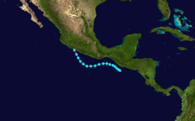
The origins of Vicente can be traced back to a tropical wave and a low-level vortex associated with the Eastern Pacific monsoon trough. The wave departed from the west coast of Africa on October 6 and reached the Lesser Antilles by October 14. A day later, convection associated with the wave diminished, with it being completely devoid of convection until October 16. The wave then crossed over Central America and entered the Eastern Pacific Ocean. Convection then redeveloped along the monsoon trough located south of Panama on October 17.[1] Early on October 19, the NHC began monitoring the trough for tropical development as it slowly travelled westward.[2] The system quickly organized over the next six hours, consolidating into Tropical Depression Twenty-Three-E by 06:00 UTC while about 90 mi (150 km) west-southwest of Puerto San Jose, Guatemala.[1] At that time, the depression was located in a favorable environment with sea surface temperatures of 28–29 °C (82–84 °F) and low vertical wind shear.[3] After having developed well-defined convective banding, the system was upgraded to a tropical storm. At that time, Vicente was traveling towards northwest under the influence of a mid-level ridge, which was situated over northern Mexico and the Gulf of Mexico.[4]
Soon after, Vicente began to be affected by 10–15 knots (12–17 mph; 19–28 km/h) of northwesterly wind shear as it paralleled the Guatemalan coast. Due to Vicente's small size, the wind shear caused it to quickly become disorganized. The storm's low-level center was almost entirely exposed as it accelerated away from its deteriorating central dense overcast.[5]
See also
[edit]- Other storms of the same name
- Hurricane Carlos (2015) – Another unusually small tropical cyclone that took a similar path
- Tropical Storm Odile (2008) – Another October tropical storm with a similar path and intensity
References
[edit]- ^ a b Beven II, John L.; Latto, Andrew S. (10 April 2019). Tropical Cyclone Report: Tropical Storm Vicente (PDF). National Hurricane Center (Report). National Oceanic and Atmospheric Administration. Retrieved 28 April 2019.
- ^ Zelinsky, David (19 October 2018). Tropical Weather Outlook. National Hurricane Center (Report). National Oceanic and Atmospheric Administration. Retrieved 1 May 2019.
- ^ Berg, Robbie (19 October 2018). Tropical Depression Twenty-Three-E Discussion Number 1. National Hurricane Center (Report). National Oceanic and Atmospheric Administration. Retrieved 1 May 2019.
- ^ Berg, Robbie (19 October 2018). Tropical Storm Vicente Discussion Number 2. National Hurricane Center (Report). National Oceanic and Atmospheric Administration. Retrieved 6 May 2019.
- ^ Zelinsky, David (20 October 2018). Tropical Storm Vicente Discussion Number 3. National Hurricane Center (Report). National Oceanic and Atmospheric Administration. Retrieved 6 May 2019.
External links
[edit]- The National Hurricane Center's advisory archive on Tropical Storm Vicente

