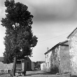
Tatre, Hrpelje-Kozina
Appearance
Tatre | |
|---|---|
Village | |
 Tatre in 1955 | |
| Coordinates: 45°35′52.2″N 14°5′10.21″E / 45.597833°N 14.0861694°E | |
| Country | |
| Traditional region | Littoral |
| Statistical region | Coastal–Karst |
| Municipality | Hrpelje-Kozina |
| Area | |
• Total | 6.85 km2 (2.64 sq mi) |
| Elevation | 742 m (2,434 ft) |
| Population (2002) | |
• Total | 54 |
| [1] | |
Tatre (pronounced [ˈtaːtɾɛ]) is a village in the Municipality of Hrpelje-Kozina in the Littoral region of Slovenia close to the border with Croatia.[2]
The local church is dedicated to Saint John the Evangelist and belongs to the Parish of Pregarje.[3]
References
[edit]External links
[edit] Media related to Tatre, Hrpelje–Kozina at Wikimedia Commons
- Tatre on Geopedia


