Tanamarina Sakay
Appearance
Tanamarina Sakay | |
|---|---|
| Coordinates: 22°28′S 46°37′E / 22.467°S 46.617°E | |
| Country | |
| Region | Haute Matsiatra |
| District | Ikalamavony |
| Area | |
• Total | 1,205 km2 (465 sq mi) |
| Elevation | 799 m (2,621 ft) |
| Population (2018) | |
• Total | 9,235 |
| Time zone | UTC3 (EAT) |
| Postal code | 314 |
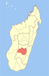
Tanamarina Sakay is a rural municipality in Madagascar. It belongs to the district of Ikalamavony, which is a part of Haute Matsiatra Region. The population of the commune was estimated to be approximately 9,235 in 2018. [2]
Villages: this municipality is constituted by the villages Sakay, Fompohony, Ambalamahasoa, Antsamby and Manomboarivo.[3]
References and notes
[edit]- ^ biblio.univ-antananarivo.mg
- ^ "ILO census data". Cornell University. 2002. Retrieved 2008-05-01.
- ^ biblio.univ-antananarivo.mg


