Ambohimahasoa District
Appearance
Ambohimahasoa | |
|---|---|
 Ambohimahasoa | |
| Coordinates: 21°06′23″S 47°12′58″E / 21.10639°S 47.21611°E | |
| Country | |
| Region | Haute Matsiatra |
| District | Ambohimahasoa District |
| Area | |
| • Total | 1,962 km2 (758 sq mi) |
| Population (2018) | |
| • Total | 271,233 |
| Census | |
| Postal code | 305 |
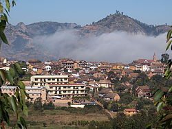
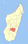
Ambohimahasoa District is a district[2] in central Madagascar. It is part of Haute Matsiatra Region. Its capital is Ambohimahasoa.
Communes
[edit]The district is further divided into 17 communes:
- Ambalakindresy
- Ambatosoa
- Ambohimahasoa
- Ambohinamboarina
- Ampitana
- Ankafina-Tsarafidy
- Ankerana
- Befeta
- Camp Robin
- Fiadanana
- Isaka
- Ikalalao
- Manandroy
- Morafeno
- Sahatona
- Sahave
- Vohiposa
Roads
[edit]The district is crossed by two national roads: the National road 7 and the National road 25.
References
[edit]- ^ RAZANADRAKOTO Norovoahangy Rijaniaina (27 February 2007). "Etude des ressources en eau de la centrale hydroélectrique d'Ambohimahasoa" (PDF). Université d’Antananarivo (in French). Retrieved 20 November 2021.
- ^ "GeoHive: Madagascar statistics". Archived from the original on 2009-04-23. Retrieved 2009-05-31.


