Sumar, Netherlands
Sumar
Suameer | |
|---|---|
Village | |
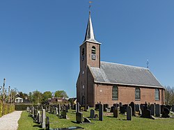
 Sumar, church: de Dorpskerk | |
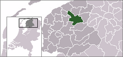
 Location of the village in Tytsjerksteradiel | |
| Coordinates: 53°11′36″N 6°0′54″E / 53.19333°N 6.01500°E | |
| Country | |
| Province | |
| Municipality | |
| Area | |
| • Total | 11.69 km2 (4.51 sq mi) |
| Elevation | 1.2 m (3.9 ft) |
| Population (2021)[1] | |
| • Total | 1,355 |
| • Density | 120/km2 (300/sq mi) |
| Postal code | 9262[1] |
| Dialing code | 0511 |
Sumar (Dutch: Suameer) is a village in the municipality of Tytsjerksteradiel, in the province of Friesland, the Netherlands. It lies south of Burgum, on the N356, and had a population of approximately 1,382 in January 2017.[3]
There is a windmill in the village, De Hoop.[4]
History
[edit]The village was first mentioned in 1453 as suwamer, and means "southern lake". Su (south) was added to distinguish between Eastermar and Noordermeer.[5] Sumar developed in the late middle ages as a collection of spread out farms around the church.[6] The Dutch Reformed church was built in 1769 as a replacement of an earlier church.[6]
Sumar was home to 457 people in 1840.[7] Around 1900, the heath in the area was cultivated.[4] The dairy factory De Harste was built 1908 and is a combination of rational and Jugendstil architecture.[6] The north of the village near the Prinses Margrietkanaal started to industrialize.[7]
The school teacher Kornelis Lieuwes de Vries developed the Bintje potato in 1898 which became one of the most popular potato varieties. The potato was named after the 17-year old Bintje Jansma, one of his students, in 1905.[7]
Gallery
[edit]-
House in Sumar
-
House on the heath
-
Former dairy factory
-
Windmill De Hoop
References
[edit]- ^ a b c "Kerncijfers wijken en buurten 2021". Central Bureau of Statistics. Retrieved 5 April 2022.
- ^ "Postcodetool for 9262MA". Actueel Hoogtebestand Nederland (in Dutch). Het Waterschapshuis. Retrieved 5 April 2022.
- ^ Overzicht inwonersaantal Tytsjerksteradiel - Tytsjerksteradiel
- ^ a b "Sumar". Friesland Wonderland (in Dutch). Retrieved 5 April 2022.
- ^ "Sumar - (geografische naam)". Etymologiebank (in Dutch). Retrieved 5 April 2022.
- ^ a b c Ronald Stenvert & Sabine Broekhoven (2000). "Sumar" (in Dutch). Zwolle: Waanders. ISBN 90 400 9476 4. Retrieved 5 April 2022.
- ^ a b c "Sumar". Plaatsengids (in Dutch). Retrieved 5 April 2022.


