Stringtown, Sullivan County, Indiana
Appearance
Stringtown | |
|---|---|
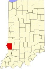
 Sullivan County's location in Indiana | |
Location in Sullivan County, Indiana | |
| Coordinates: 39°03′12″N 87°17′51″W / 39.05333°N 87.29750°W | |
| Country | United States |
| State | Indiana |
| County | Sullivan |
| Township | Cass |
| Elevation | 561 ft (171 m) |
| Time zone | UTC-5 (Eastern (EST)) |
| • Summer (DST) | UTC-4 (EDT) |
| ZIP code | 47882 |
| Area code(s) | 812, 930 |
| GNIS feature ID | 444270 |
Stringtown is an unincorporated community in Cass Township, Sullivan County, in the U.S. state of Indiana.[2] There are several communities in the state that carry the name.
The community is part of the Terre Haute Metropolitan Statistical Area.
Geography
[edit]Stringtown is located at 39°03′12″N 87°17′51″W / 39.05333°N 87.29750°W.
References
[edit]- ^ "US Board on Geographic Names". United States Geological Survey. October 25, 2007. Retrieved September 28, 2016.
- ^ "Stringtown, Sullivan County, Indiana". Geographic Names Information System. United States Geological Survey. Retrieved August 5, 2017.


