Pleasantville, Indiana
Appearance
Pleasantville, Indiana | |
|---|---|
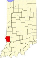
 Sullivan County's location in Indiana | |
| Coordinates: 38°58′01″N 87°15′01″W / 38.96694°N 87.25028°W | |
| Country | United States |
| State | Indiana |
| County | Sullivan |
| Township | Jefferson |
| Elevation | 545 ft (166 m) |
| Time zone | UTC-5 (Eastern (EST)) |
| • Summer (DST) | UTC-4 (EDT) |
| ZIP code | 47838 |
| Area code(s) | 812, 930 |
| FIPS code | 18-60732[2] |
| GNIS feature ID | 441356 |
Pleasantville is an unincorporated community in Jefferson Township, Sullivan County, in the U.S. state of Indiana.[3]
The community is part of the Terre Haute Metropolitan Statistical Area.
History
[edit]A post office was established at Pleasantville in 1865, and remained in operation until it was discontinued in 1964.[4]
Geography
[edit]Pleasantville is located at 38°58′01″N 87°15′01″W / 38.96694°N 87.25028°W.
Education
[edit]Pleasantville's high school, built in 1916, closed in 1965 when it was consolidated into Union High School in nearby Dugger. However, the high school gym, constructed in 1954, is still used by the community. It hosted a Union High School basketball game in the 2014–15 season, with the Union team wearing Pleasantvllle Blue Streak uniforms.[5]
References
[edit]- ^ "US Board on Geographic Names". United States Geological Survey. October 25, 2007. Retrieved January 31, 2008.
- ^ "U.S. Census website". United States Census Bureau. Retrieved January 31, 2008.
- ^ "Pleasantville, Indiana". Geographic Names Information System. United States Geological Survey. Retrieved August 5, 2017.
- ^ "Sullivan County". Jim Forte Postal History. Retrieved September 28, 2016.
- ^ Neddenriep, Kyle (July 12, 2018). "An Indiana gym gem: Restoration of Pleasantville gym a pleasant surprise". Indianapolis Star. Retrieved July 13, 2018.


