Stolp Synagogue
Appearance
| Stolp Synagogue | |
|---|---|
Polish: Synagoga Słupsk | |
 The former synagogue, now destroyed, undated | |
| Religion | |
| Affiliation | Judaism (former) |
| Ecclesiastical or organisational status | Synagogue (1902–1938) |
| Status | Destroyed |
| Location | |
| Location | Słupsk, Pomeranian Voivodeship (formerly Stolp) |
| Country | Poland (formerly Germany) |
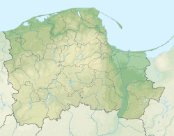
Location of the destroyed synagogue in Pomeranian Voivodeship, Poland | |
| Geographic coordinates | 54°28′05″N 17°01′33″E / 54.46806°N 17.02583°E |
| Architecture | |
| Architect(s) | Eduard Koch |
| Type | Synagogue architecture |
| Groundbreaking | 1901 |
| Completed | 1902 |
| Destroyed | 10 November 1938 (during Kristallnacht) |
The Stolp Synagogue (Polish: Synagoga Słupsk) was a former Jewish congregation and synagogue, now destroyed, that was located in Stolp, Germany, that is now Słupsk, in the Pomeranian Voivodeship of Poland.[1]
Designed by Eduard Koch, the synagogue was completed in 1902 and destroyed by Nazis during Kristallnacht, on November 10, 1938.
An unveiling ceremony for a monument commemorating the Jewish community of the city, was held in 2006, organized by the Foundation for the Preservation of Jewish Heritage in Poland.[2]
See also
[edit]- History of the Jews in Germany
- History of the Jews in Poland
- List of synagogues in Germany (in German)
- List of active synagogues in Poland
References
[edit]- ^ "Nowa synagoga". Wirtualny Sztetl (in Polish). Retrieved July 14, 2020.
- ^ "Fundacja Ochrony Dziedzictwa Żydowskiego". fodz.pl (in Polish). Retrieved July 14, 2020.
External links
[edit] Media related to Synagogue in Słupsk at Wikimedia Commons
Categories:
- 1938 disestablishments in Germany
- 20th-century synagogues in Germany
- Buildings and structures destroyed in 1938
- Buildings and structures in Słupsk
- Former synagogues in Poland
- Synagogues completed in 1902
- Synagogues destroyed during Kristallnacht (Germany)
- Religious buildings and structures in Pomeranian Voivodeship
- European synagogue stubs
- Polish religious building and structure stubs
- German religious building and structure stubs

