
Southern Zone Sea

The Sea of the Southern Zone (Spanish: Mar de la Zona Austral)[1] or Southern Zone Sea is the name given by Argentina and Chile to the maritime area whose boundaries were undefined, located south of the Isla Grande de Tierra del Fuego. This maritime space was subject to delimitation in the Treaty of Peace and Friendship of 1984 between Chile and Argentina, which ended the Beagle conflict or "Southern Zone conflict."
The definition of this maritime area was constrained by the necessity for the parties ratifying the treaty to avoid referring to the area under delimitation as part of either the Atlantic Ocean or the Pacific Ocean, since the two countries could not agree on its affiliation to one ocean or the other. After the signing of the treaty in 1984 and its ratification in 1985, the name "Sea of the Southern Zone" has been largely ignored in both countries, which continue to use their traditional names in cartographic representations of the area. For this reason, parts of this sea are sometimes linked to the Argentine Sea, Chilean Sea or the Drake Passage.
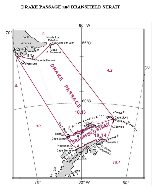
The name "Sea of the Southern Zone" has not been adopted internationally, and the International Hydrographic Organization did not include the Sea of the Southern Zone in the draft of the 4th edition of its publication Limits of Oceans and Seas, issued via Circular CL55 of 7 November 2001 (the 3rd edition dates from 1953).[2] In this draft, Chile, in agreement with Russia and the United Kingdom, proposed as the northern limit of the Drake Passage the line connecting Waterman Island, Cape Horn, Cape San Bartolomé on Isla de los Estados, and the southern coast of that island to Cape San Juan de Salvamento, clearly overlapping areas under the delimitation of the Sea of the Southern Zone.[3]
Boundaries
[edit]The boundaries of the Sea of the Southern Zone have only been precisely defined in its northern part, where it reaches the shores of Isla de los Estados from its eastern extremity, the mouth of the Le Maire Strait, and the coast on the Isla Grande de Tierra del Fuego to the eastern mouth of the Beagle Channel at Cape San Pío. To the west, it extends at least to the Chilean straight baselines — though it is unclear whether it extends further west — which skirt the southeast coast of Isla Nueva, the Evout and Barnevelt islets, Deceit Island, and Hornos Island, continuing south to the meridian of Cape Horn. The eastern boundary has not been defined, reaching at least the polygonal line defined in the treaty between points A and E, leaving the connection between point F of the polygon and the eastern extremity of Isla de los Estados undefined. It is not specified whether it extends to the limit of the Argentine exclusive economic zone that was part of the conflict.
Natural delimitation between the Pacific and South Atlantic oceans by the Shackleton Fracture Zone
[edit]
The researchers Juan Ignacio Ipinza Mayor and Cedomir Marangunic Damianovic put forward the scientific theory that the separation of the Pacific and Atlantic Ocean oceans "could be confirmed from the so-called Shackleton Fracture Zone ... the boundary is then located east of the so-called Cape Horn Meridian".[4]
Dispute over the extended continental shelf
[edit]
The United Nations Convention on the Law of the Sea (UNCLOS) of April 30, 1982, which entered into force on November 16, 1994, established the regime of the continental shelf in Part VI (Articles 76 to 85), defining in Article 76, paragraph 1 what is understood as a continental shelf.
Argentina ratified the convention on January 12, 1995, and it came into force for the country on December 31, 1995.
On August 25, 1997, Chile signed and ratified the United Nations Convention on the Law of the Sea, and it entered into force for the country on September 24, 1997.[5]
In 2009, Argentina submitted a presentation to the United Nations Commission on the Limits of the Continental Shelf, which was accepted in 2016 by the UNCLOS.[6] The map in the submission included the disputed territories with the United Kingdom, such as the Falkland Islands, South Georgia, and South Sandwich Islands, a crescent-shaped area south of Argentina's territorial sea as defined in the 1984 treaty with Chile.[7] This area was also claimed by Chile as part of its presential sea,[8] and the sea surrounding the Antarctic Peninsula, which is claimed by all three aforementioned countries.[9] That same year, on May 8, Chile submitted its Preliminary Report to the United Nations Commission on the Limits of the Continental Shelf.[10][11][12]
In 2020, the Argentine Chamber of Deputies unanimously approved the outer limit of the Argentine Continental Shelf in Law 27,557.[13]
That same year, on December 21, Chile submitted to the United Nations Commission on the Limits of the Continental Shelf the partial report on the extended continental shelf in Easter Island and Salas y Gómez.[14][15]
In 2021, Chilean President Sebastián Piñera signed Supreme Decree No. 95, which outlined the continental shelf east of the 67º 16' 0 meridian as part of Chile's continental shelf (not the extended one) area projected from the Diego Ramírez Islands, also claiming the crescent area that Argentina considers part of its extension achieved under the extended continental shelf principle.[16][17][18] This was reflected in the SHOA Chart No. 8[19] and prompted a response from the Argentine Foreign Ministry against Chile's measure.[20][21][22][23][24][25][26][27]
In February 2022, Chile submitted its second partial presentation regarding the Western Continental Shelf of the Chilean Antarctic Territory.[28][29] In August of the same year, Chile made the oral presentations of both partial submissions during the 55th Session of the Commission on the Limits of the Continental Shelf at the United Nations in New York.[30][5]
In 2023, Chile, through SHOA, made available an illustrative graphic showing all the maritime areas claimed by the country, which was once again rejected by Argentina.[31][32][33][34]
In July 2023, the International Court of Justice ruled on the priority of a Continental Shelf over a Extended Continental Shelf in the case of the territorial and maritime dispute between Colombia and Nicaragua.[35]Notes and references
[edit]- ^ The 1984 Treaty says about the maritime border: Artículo 7°. El límite entre las respectivas soberanías sobre el mar, suelo y subsuelo de la República Argentina y de la República de Chile en el Mar de la Zona Austral a partir del término de la delimitación existente en el Canal Beagle,...
- ^ Circular CL55 of 2001
- ^ Map of the proposed limits for the Drake Passage submitted to the IHO
- ^ Juan Ignacio Ipinza Mayor; Cedomir Marangunic Damianovic (2021). "ALGUNAS CONSECUENCIAS JURÍDICAS DE LA INVOCACIÓN POR PARTE DE CHILE DE LA "TEORÍA DE LA DELIMITACIÓN NATURAL DE LOS OCÉANOS" EN EL DIFERENDO SOBRE LA PLATAFORMA CONTINENTAL AUSTRAL". ANEPE (in Spanish).
- ^ a b "Proyecto Plataforma Continental de Chile". Government of Chile. 2023. Retrieved October 21, 2024.
- ^ "Argentina presents territorial claim". BBC. April 21, 2009. Retrieved October 18, 2024.
- ^ "Crescent beyond point F of the 1984 Treaty of Peace and Friendship: new maritime dispute with Argentina". El Mostrador. March 23, 2023. Retrieved October 18, 2024.
- ^ Lieutenant Commander Luis Kohler Gary (March 2001). "The Presential Sea of Chile. Its current challenge" (PDF). Revista Marina.
- ^ Fulvio Rossetti (August 2021). "No man's land, everyone's land. Unity and nature in the cultural figures of the Antarctic Peninsula and surrounding areas". Revista 180. Retrieved October 18, 2024.
- ^ "Información Preliminar Indicativa de los límites exteriores de la Plataforma Continental y una descripción del estado de preparación y de la fecha prevista de envío de la presentación a la Comisión de Límites de la Plataforma Continental" (PDF). Government of Chile. May 2009. Retrieved October 21, 2024.
- ^ "New limits dispute arises between Chile and Argentina". Merco Press. 30 August 2021. Retrieved 23 October 2024.
- ^ "Argentina/Chile continental shelf dispute: "beware about arousing nationalism in electoral processes"". Merco Press. 7 September 2021. Retrieved 23 October 2024.
- ^ "Deputies approved two laws to strengthen sovereignty over the Malvinas" (in Spanish). Página/12. 5 August 2020. Retrieved 17 October 2024.
- ^ "Chile seeks to define the Continental Shelf of the province of Easter Island". La Prensa Austral. June 16, 2024. Retrieved November 21, 2024.
- ^ "The extended continental shelf around Easter Island and Salas y Gómez". Revista Marina. October 27, 2020. Retrieved November 21, 2024.
- ^ "Piñera: "What Chile is doing is exercising its right and declaring its continental shelf"" (in Spanish). T13. 29 August 2021. Retrieved 17 October 2024.
- ^ "Chile will ask the UN to recognize its maritime platform extension, which is already causing conflict with Argentina" (in Spanish). Infobae. 16 December 2021. Retrieved 17 October 2024.
- ^ "Diplomatic conflict between Argentina and Chile over the Continental Shelf" (PDF) (in Spanish). Ministry of Agriculture, Fisheries and Food (Spain). 14 September 2021. Retrieved 17 October 2024.
- ^ Juan Ignacio Ipinza Mayor (3 September 2021). "Southern Patagonian Ice Field and SHOA Chart No. 8" (in Spanish). InfoGate. Retrieved 15 December 2023.
- ^ "After decrees: Argentina accuses Chile of trying to "appropriate" the southern continental shelf" (in Spanish). T13. 28 August 2021. Retrieved 17 October 2024.
- ^ "Argentina claims Chile over an area it does not yet own". Revista Puerto. 30 August 2021. Retrieved 17 October 2024.
- ^ "Foreign Minister Allamand states that "it seems unnecessary to engage in further public debate" with Argentina over the continental shelf". Emol. September 2, 2021. Retrieved October 17, 2024.
- ^ "Solá rejected the document signed by the PRO on the continental shelf: "They deny our rights," he said". Realidad Sanmartinense. August 31, 2021. Retrieved October 17, 2024.
- ^ "Chile vs. Argentina por la plataforma continental en el Mar Austral: perspectivas". La Capital de Mar del Plata. October 5, 2021. Retrieved October 18, 2024.
- ^ "Plataforma continental chilena en el mar de la zona austral, un interés esencial del Estado". CEP Chile. January 28, 2023. Retrieved October 18, 2024.
- ^ "Chile and Argentina agree to discuss ongoing continental shelf differences south of Cape Horn". Merco Press. 30 August 2021. Retrieved 23 October 2024.
- ^ 7 September 2021. "Argentina sends Chile diplomatic note rejecting their "expansive vocation"". Merco Press. Retrieved 23 October 2024.
{{cite web}}: CS1 maint: numeric names: authors list (link) - ^ "Plataforma Continental Occidental del Territorio Chileno Antártico" (PDF). National Committee for the Continental Shelf - Chile. February 28, 2022. Retrieved October 21, 2024.
- ^ "Chile to present the extended continental shelf west of Antarctica to the UN". Info Defensa. December 16, 2021. Retrieved October 17, 2024.
- ^ "Chile realiza sus presentaciones orales de Plataforma Continental extendida de Isla de Pascua y Antártica a la Comisión de Límites de la Plataforma Continental en Naciones Unidas". DIFROL. August 10, 2022. Retrieved October 21, 2024.
- ^ "SHOA makes available an illustrative graphic of Chilean maritime jurisdiction areas". Armada de Chile. August 23, 2023. Retrieved October 17, 2024.
- ^ "Continental shelf: The stance Chile has maintained in response to Argentina's objections and the new frustration over SHOA maps". Emol. August 29, 2023. Retrieved October 17, 2024.
- ^ "Argentine Foreign Ministry sends formal complaint to Chile over Navy map including continental shelf". Emol. August 29, 2023. Retrieved October 17, 2024.
- ^ "Argentina protests over map with continental shelf created by Chilean Navy". Nuevo Poder. August 29, 2023. Retrieved October 17, 2024.
- ^ "Nueva controversia en el mar de la zona austral". August 31, 2024. Retrieved October 18, 2024.