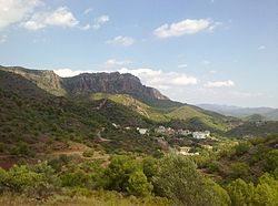
Segart
Appearance
Segart | |
|---|---|
 | |
| Coordinates: 39°41′0″N 0°22′25″W / 39.68333°N 0.37361°W | |
| Country | |
| Autonomous community | |
| Province | Valencia |
| Comarca | Camp de Morvedre |
| Judicial district | Sagunt |
| Government | |
| • Mayor | Paco Garriga (JPS) |
| Area | |
• Total | 6.60 km2 (2.55 sq mi) |
| Elevation | 300 m (1,000 ft) |
| Population (2018)[1] | |
• Total | 158 |
| • Density | 24/km2 (62/sq mi) |
| Demonym | Segartí/Segartina |
| Time zone | UTC+1 (CET) |
| • Summer (DST) | UTC+2 (CEST) |
| Postal code | 46592 |
| Language | Valencian (Catalan) |
| Website | Official website |
Segart is a town in the autonomous community of Valencia, Spain, belonging to the province of Valencia in the comarca of Camp de Morvedre. Until the mid-20th century, it was called Segart of Albalat.
Economy
[edit]Economy is traditionally based on agriculture, with cultivation of olives, almonds, carob and vine. Irrigated areas grow oranges. Livestock include sheep.
Main sights
[edit]- Hermitage of Segart
- Parish church, dedicated to the Immaculate Conception.
- Segart Castle, of Moorish (13th century) origins, conquered by James I of Aragon. It is situated atop a hill.
- El Garbí panoramic point ov view.
References
[edit]- ^ Municipal Register of Spain 2018. National Statistics Institute.
External links
[edit]


