Sarıoğlan
Appearance
Sarıoğlan | |
|---|---|
District and municipality | |
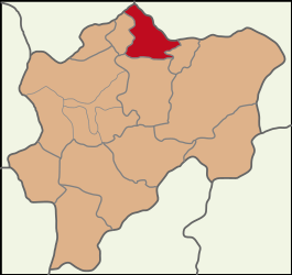
 Map showing Sarıoğlan District in Kayseri Province | |
| Coordinates: 39°04′37″N 35°58′0″E / 39.07694°N 35.96667°E | |
| Country | Turkey |
| Province | Kayseri |
| Government | |
| • Mayor | Bekir Ayyıldırım (MHP) |
| Area | 642 km2 (248 sq mi) |
| Population (2022)[1] | 13,396 |
| • Density | 21/km2 (54/sq mi) |
| Time zone | UTC+3 (TRT) |
| Postal code | 38820 |
| Area code | 0352 |
| Website | www |
Sarıoğlan is a municipality and district of Kayseri Province, Turkey.[2] Its area is 642 km2,[3] and its population is 13,396 (2022).[1] The mayor is Bekir Ayyıldırım (MHP).
Composition
[edit]There are 28 neighbourhoods in Sarıoğlan District:[4]
- Alamettin
- Bakarcak
- Burunören
- Çiftlik
- Düzencik
- Ebülhayır
- Gaziler
- Güzelyazı
- Hürriyet
- İğdeli
- Ilıca
- Kadılı
- Kaleköy
- Karaözü
- Karpınar
- Keklikoğlu
- Kızılpınar
- Muratbeyli
- Ömerhacılı
- Ömürlü
- Palas
- Şenyurt
- Sofumahmut
- Tatılı
- Üzerlik
- Yahyalı
- Yerlikuyu
- Yıldırım
References
[edit]- ^ a b "Address-based population registration system (ADNKS) results dated 31 December 2022, Favorite Reports" (XLS). TÜİK. Retrieved 19 September 2023.
- ^ Büyükşehir İlçe Belediyesi, Turkey Civil Administration Departments Inventory. Retrieved 19 September 2023.
- ^ "İl ve İlçe Yüz ölçümleri". General Directorate of Mapping. Retrieved 19 September 2023.
- ^ Mahalle, Turkey Civil Administration Departments Inventory. Retrieved 19 September 2023.


