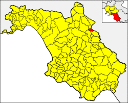
Salvitelle
Appearance
You can help expand this article with text translated from the corresponding article in Italian. (January 2022) Click [show] for important translation instructions.
|
Salvitelle | |
|---|---|
| Comune di Salvitelle | |
 | |
 Salvitelle within the Province of Salerno | |
| Coordinates: 40°36′N 15°28′E / 40.600°N 15.467°E | |
| Country | Italy |
| Region | Campania |
| Province | Salerno (SA) |
| Area | |
• Total | 9 km2 (3 sq mi) |
| Elevation | 630 m (2,070 ft) |
| Population (1 December 2009)[2] | |
• Total | 609 |
| • Density | 68/km2 (180/sq mi) |
| Demonym | Salvitellesi |
| Time zone | UTC+1 (CET) |
| • Summer (DST) | UTC+2 (CEST) |
| Postal code | 84020 |
| Dialing code | 0975 |
| ISTAT code | 065117 |
| Patron saint | San Sebastiano |
| Saint day | 20 January and the last Sunday in August |
| Website | Official website |
Salvitelle (Campanian: Salvtell) is a town and comune in the province of Salerno in the Campania region of southwestern Italy.
Geography
[edit]The municipality borders with Auletta, Buccino, Caggiano, Romagnano al Monte and Vietri di Potenza (PZ).
Monuments and Places of Interest
[edit]This section is written like a travel guide. (January 2022) |
- Chapel of St. Sebastian (1557-1558),
- Church of SS. Rosario (1740),
- Church of the Holy Spirit (1800),
- Grassibelli Palace,
- Mucci Palace,
- Romanzi Palace,
- Briganti Palace.
References
[edit]- ^ "Superficie di Comuni Province e Regioni italiane al 9 ottobre 2011". Italian National Institute of Statistics. Retrieved 16 March 2019.
- ^ All demographics and other statistics from the Italian statistical institute (Istat); Dati - Popolazione residente all'1/4/2009
External links
[edit]![]() Media related to Salvitelle at Wikimedia Commons
Media related to Salvitelle at Wikimedia Commons


