Salisbury Beach State Reservation
| Salisbury Beach State Reservation | |
|---|---|
 | |
| Location | Essex County, Massachusetts, United States |
| Coordinates | 42°49′35.4″N 70°49′2.8″W / 42.826500°N 70.817444°W |
| Area | 355 acres (144 ha)[1] |
| Elevation | 10 ft (3.0 m)[2] |
| Established | 1931[3] |
| Operator | Massachusetts Department of Conservation and Recreation |
| Website | Salisbury Beach State Reservation |
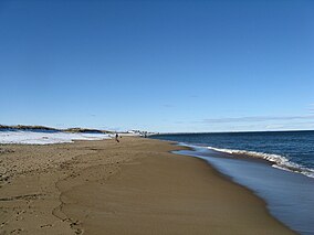
Salisbury Beach State Reservation is a state-owned, public recreation area on the Atlantic Ocean in the town of Salisbury, Massachusetts, managed by the Massachusetts Department of Conservation and Recreation.[4] It is one of the most heavily utilized state parks in the Commonwealth, with "an annual attendance rate of over one million visitors."[5]
History
[edit]During the American Civil War the Fort at Salisbury Point was built on the site, which was eventually lost due to beach erosion.[6] The land was acquired for use as a state park in 1931.[3] It saw improvements in the following decade done by the Works Progress Administration and the Civilian Conservation Corps.[7] During World War II the site included a gun battery as the Salisbury Beach Military Reservation.[8] The reservation came under the jurisdiction of the Department of Conservation and Recreation in 1969.[5] Continuing park improvements include the construction of a new jetty in 2015.[4] In March 2024, coastal flooding eroded 7,500 tons of sand placed on the beach at a cost of $600,000 as part of a beachfront restoration effort by local property owners.[9]
Wildlife
[edit]Notable wildlife includes harbor seals, which are often found on Badgers Rocks in the Merrimack River in the fall and winter. Birds that can be sighted include black ducks, green-winged teal, and great blue herons, along with pectoral, solitary, and least sandpipers.[5] "White-winged and surf scoters can be seen flying low over open water or bobbing in loose flocks among the offshore waves."[10]
Activities and amenities
[edit]- Beaches: The park features a 3.8-mile-long (6.1 km) beach on the Atlantic Ocean. Beaches and restrooms are handicapped-accessible.[4] Smaller, non-swimming beaches are found on the Merrimack River.[11]
- Camping: The park's 484-site campground includes handicapped-accessible sites as well as RV hookups and dump station.
- Boating: Motorized and non-motorized boating can be accessed from two boat ramps on the Merrimack River.
- The park also offers showers, picnicking, a playground and pavilion, fishing, restricted hunting, a group day-use area, and educational programs.
- Fees: In 2024, the park entrance fee was $14 a day for Massachusetts residents and $40 for visitors from out of state.[12]
References
[edit]- ^ "2012 Acreage Listing" (PDF). Department of Conservation and Recreation. April 2012. Retrieved January 19, 2014.
- ^ "Salisbury Beach State Reservation". Geographic Names Information System. United States Geological Survey, United States Department of the Interior.
- ^ a b Massachusetts (June 30, 1931). "Chapter 442. An act ... authorizing the taking for maintenance as a state reservation of certain parcels of land at Salisbury Beach" (PDF). Acts, 1931. Retrieved September 20, 2015.
- ^ a b c "Salisbury Beach State Reservation". MassParks. Executive Office of Energy and Environmental Affairs. Retrieved August 5, 2013.
- ^ a b c "Salisbury Beach State Reservation Barrier Beach Management Plan" (PDF). Department of Conservation and Recreation. September 2008. Retrieved September 20, 2015.
- ^ "Massachusetts". American Forts Network. Retrieved June 15, 2020.
- ^ Shary Page Berg (1999). Beth McKinney (ed.). "The Civilian Conservation Corps: A Statewide Survey of Civilian Conservation Corps Resources". Massachusetts Office of Historic Resources. p. 41. Retrieved September 18, 2015.
- ^ Salisbury Beach Base-End Station and 155 mm Gun Battery at American Forts Network
- ^ Berger, Ava; Hempel-Edgers, Lila (March 13, 2024). "Coastal flooding washes away half of $600,000 effort, paid for by property owners, to save sand dunes on Salisbury Beach". The Boston Globe. Retrieved March 13, 2024.
- ^ "Salisbury Beach State Reservation". Wildlife Viewing Areas. Watchable Wildlife, Inc. Retrieved February 4, 2014.
- ^ "Salisbury Beach Visitor's Guide". Retrieved August 5, 2013.
- ^ https://www.mass.gov/locations/salisbury-beach-state-reservation
External links
[edit]- Salisbury Beach State Reservation Department of Conservation and Recreation


