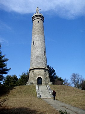
Myles Standish Monument State Reservation
| Myles Standish Monument State Reservation | |
|---|---|
 Myles Standish Monument | |
| Location | Duxbury, Plymouth, Massachusetts, United States |
| Coordinates | 42°00′50″N 70°41′11″W / 42.01389°N 70.68639°W |
| Area | 30 acres (12 ha)[1] |
| Elevation | 200 ft (61 m)[2] |
| Established | 1872 |
| Governing body | Massachusetts Department of Conservation and Recreation |
| Website | Myles Standish Monument State Reservation |
Myles Standish Monument State Reservation is a state-owned historic preserve and public recreation area in Duxbury, Massachusetts. The focus of the state park is a 116-foot granite shaft topped by a statue of Captain Myles Standish. Standish was military leader of Plymouth Colony. The park is managed by the Massachusetts Department of Conservation and Recreation.[3]
History
[edit]A dedication and cornerstone-laying ceremony attended by 10,000 people took place on October 7, 1872. The monument was not completed until 1898. The monument was built on Captain's Hill, the highest point, 200 feet above sea level, on what was once Standish's farm. The monument rises 116 feet from its foundation to a small viewing parapet that offers panoramic views over the original Plymouth Colony. The 14-foot statue that surmounts the tower has Standish gazing eastward across Massachusetts Bay and holding the colony's charter. The Commonwealth of Massachusetts has owned the monument and grounds since 1920.[4] The monument was refurbished in 1988.[3]
Activities and amenities
[edit]The tower's 125 steps can be climbed when open, yielding views from the top of 19th-century lighthouses, Duxbury Beach, Plymouth Harbor, and the Blue Hills to the northwest. The park offers walking trails, picnic tables, and seasonal interpretive programs.[3]
Nearby is Myles Standish Burial Ground, the final resting place for the Captain, with a second, smaller monument built over his gravesite.[5]
References
[edit]- ^ "2012 Acreage Listing" (PDF). Department of Conservation and Recreation. April 2012. Retrieved January 19, 2014.
- ^ "Myles Standish State Park". Geographic Names Information System. United States Geological Survey, United States Department of the Interior.
- ^ a b c "Myles Standish Monument State Reservation". MassParks. Executive Office of Energy and Environmental Affairs. Retrieved August 20, 2013.
- ^ "Duxbury Dedicates Standish Monument". Mass Moments. Massachusetts Foundation for the Humanities. Retrieved September 14, 2015.
- ^ MainTour Duxbury
External links
[edit]- Myles Standish Monument State Reservation Department of Conservation and Recreation
- Plymouth, Massachusetts
- State parks of Massachusetts
- Massachusetts natural resources
- Duxbury, Massachusetts
- Monuments and memorials in Massachusetts
- Parks in Plymouth County, Massachusetts
- 1898 sculptures
- Granite sculptures in Massachusetts
- 1898 establishments in Massachusetts
- Statues in Massachusetts
- Sculptures of men in Massachusetts
- Monuments and memorials to the Pilgrims


