Rural Municipality of Rockwood
Rockwood | |
|---|---|
Rural Municipality | |
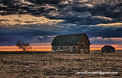
 Rural scene in Rockwood | |
 Location of the RM of Rockwood in Manitoba | |
| Coordinates: 50°17′08″N 97°17′13″W / 50.28556°N 97.28694°W | |
| Country | Canada |
| Province | Manitoba |
| Region | Winnipeg Metro |
| Government | |
| • Reeve | Wes Taplin |
| Area | |
• Total | 1,199.93 km2 (463.30 sq mi) |
| Elevation | 255 m (837 ft) |
| Population (2021)[1] | |
• Total | 8,440 |
| • Density | 7.0/km2 (18/sq mi) |
| Time zone | UTC−6 (CST) |
| • Summer (DST) | UTC−5 (CDT) |
| Postal Code | |
| Area codes | 204, 431 |
Rockwood is a rural municipality (RM) lying north of Winnipeg, Manitoba, Canada. It is part of the Winnipeg Metro Region and had a 2021 census population of 8,440.[1] The independently governed towns of Stonewall and Teulon are both enclaved within Rockwood.
Communities
[edit]Demographics
[edit]In the 2021 Census of Population conducted by Statistics Canada, Rockwood had a population of 8,440 living in 2,747 of its 2,927 total private dwellings, a change of 7.9% from its 2016 population of 7,823. With a land area of 1,184.89 km2 (457.49 sq mi), it had a population density of 7.1/km2 (18.4/sq mi) in 2021.[2]
| Panethnic group | 2021[3] | 2016[4] | 2011[5] | 2006[6] | 2001[7] | |||||
|---|---|---|---|---|---|---|---|---|---|---|
| Pop. | % | Pop. | % | Pop. | % | Pop. | % | Pop. | % | |
| European[a] | 5,875 | 82.4% | 5,900 | 85.2% | 6,300 | 89.94% | 6,500 | 92.53% | 6,425 | 91.07% |
| Indigenous | 1,110 | 15.57% | 930 | 13.43% | 545 | 7.78% | 500 | 7.12% | 465 | 6.59% |
| Southeast Asian[b] | 45 | 0.63% | 20 | 0.29% | 0 | 0% | 10 | 0.14% | 10 | 0.14% |
| East Asian[c] | 35 | 0.49% | 25 | 0.36% | 0 | 0% | 15 | 0.21% | 25 | 0.35% |
| Middle Eastern[d] | 10 | 0.14% | 15 | 0.22% | 0 | 0% | 0 | 0% | 0 | 0% |
| South Asian | 0 | 0% | 10 | 0.14% | 130 | 1.86% | 0 | 0% | 0 | 0% |
| Latin American | 0 | 0% | 25 | 0.36% | 0 | 0% | 10 | 0.14% | 0 | 0% |
| African | 0 | 0% | 15 | 0.22% | 15 | 0.21% | 0 | 0% | 125 | 1.77% |
| Other/multiracial[e] | 0 | 0% | 0 | 0% | 0 | 0% | 0 | 0% | 15 | 0.21% |
| Total responses | 7,130 | 84.48% | 6,925 | 88.52% | 7,005 | 87.96% | 7,025 | 91.33% | 7,055 | 92.17% |
| Total population | 8,440 | 100% | 7,823 | 100% | 7,964 | 100% | 7,692 | 100% | 7,654 | 100% |
| Note: Totals greater than 100% due to multiple origin responses | ||||||||||
Water
[edit]The RM of Rockwood's water is supplied by three wells in operation since 1990.[8]
When the RM applied to the Public Utilities Board for water rate increases in the late 2010s, they reported a higher amount of "unaccounted for" water usage of 17% (normal is 10%). Some of this unused water came from water line cleaning, firefighting, and water main breakage.[8] In 2017, 545 new water meters were installed to help reduce the unaccounted for water.[8]
The Stony Mountain Institution water is provided by the separate Cartier Regional Water Co-op.[8]
Notes
[edit]- ^ Statistic includes all persons that did not make up part of a visible minority or an indigenous identity.
- ^ Statistic includes total responses of "Filipino" and "Southeast Asian" under visible minority section on census.
- ^ Statistic includes total responses of "Chinese", "Korean", and "Japanese" under visible minority section on census.
- ^ Statistic includes total responses of "West Asian" and "Arab" under visible minority section on census.
- ^ Statistic includes total responses of "Visible minority, n.i.e." and "Multiple visible minorities" under visible minority section on census.
References
[edit]- ^ a b "2021 Census Profile - RM of Rockwood". statcan.gc.ca. February 9, 2022. Retrieved April 1, 2022.
- ^ "Population and dwelling counts: Canada, provinces and territories, and census subdivisions (municipalities), Manitoba". Statistics Canada. February 9, 2022. Retrieved February 20, 2022.
- ^ Government of Canada, Statistics Canada (October 26, 2022). "Census Profile, 2021 Census of Population". www12.statcan.gc.ca. Retrieved June 16, 2023.
- ^ Government of Canada, Statistics Canada (October 27, 2021). "Census Profile, 2016 Census". www12.statcan.gc.ca. Retrieved June 16, 2023.
- ^ Government of Canada, Statistics Canada (November 27, 2015). "NHS Profile". www12.statcan.gc.ca. Retrieved June 16, 2023.
- ^ Government of Canada, Statistics Canada (August 20, 2019). "2006 Community Profiles". www12.statcan.gc.ca. Retrieved June 16, 2023.
- ^ Government of Canada, Statistics Canada (July 2, 2019). "2001 Community Profiles". www12.statcan.gc.ca. Retrieved June 16, 2023.
- ^ a b c d "Rural Municipality of Rockwood Stony Mountain Water and Wastewater Utility Approval of Revised Rates" (PDF). pub.gov.mb.ca. November 9, 2018. Retrieved February 13, 2020.

