Réalville
Appearance
Réalville | |
|---|---|
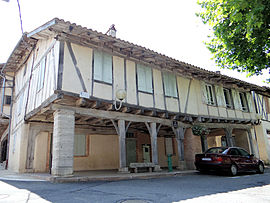
 The Place de Arcades, in Réalville | |
| Coordinates: 44°06′56″N 1°28′49″E / 44.1156°N 1.4803°E | |
| Country | France |
| Region | Occitania |
| Department | Tarn-et-Garonne |
| Arrondissement | Montauban |
| Canton | Quercy-Aveyron |
| Intercommunality | Quercy caussadais |
| Government | |
| • Mayor (2020–2026) | André Mourgues[1] |
Area 1 | 25.09 km2 (9.69 sq mi) |
| Population (2021)[2] | 1,863 |
| • Density | 74/km2 (190/sq mi) |
| Time zone | UTC+01:00 (CET) |
| • Summer (DST) | UTC+02:00 (CEST) |
| INSEE/Postal code | 82149 /82440 |
| Elevation | 79–210 m (259–689 ft) (avg. 40 m or 130 ft) |
| 1 French Land Register data, which excludes lakes, ponds, glaciers > 1 km2 (0.386 sq mi or 247 acres) and river estuaries. | |
Réalville (French pronunciation: [ʁealvil]; Occitan: Realvila) is a commune in the Tarn-et-Garonne department in the Occitanie region in southern France.
History
[edit]The town was founded by King Philip the Fair and built instead of Gardemont; it replaced what existed in Almont, which was then demolished and whose materials were used in part for the construction of the new town. Philip the Fair gave Réalville a Charter of Customs by a decree dated at Poissy in January 1310, the date considered to be that of the founding of the city.
From 1939 to 1940, an Internment camp of France was established on the municipal territory, hosting the 533rd and 534th Foreign workers group, until June 1940.
See also
[edit]References
[edit]- ^ "Répertoire national des élus: les maires" (in French). data.gouv.fr, Plateforme ouverte des données publiques françaises. 13 September 2022.
- ^ "Populations légales 2021" (in French). The National Institute of Statistics and Economic Studies. 28 December 2023.
Wikimedia Commons has media related to Réalville.


