Qaleh Ganj County
Qaleh Ganj County
Persian: شهرستان قلعه گنج | |
|---|---|
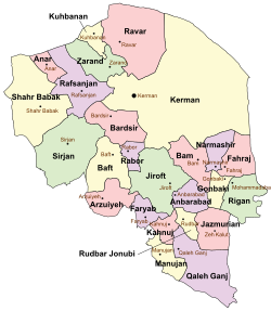
 Location of Qaleh Ganj County in Kerman province (bottom, purple) | |
 Location of Kerman province in Iran | |
| Coordinates: 27°14′N 58°26′E / 27.233°N 58.433°E[1] | |
| Country | Iran |
| Province | Kerman |
| Capital | Qaleh Ganj |
| Districts | Central, Chah Dadkhoda, Sorkh Qaleh |
| Population (2016)[2] | |
| • Total | 76,495 |
| Time zone | UTC+3:30 (IRST) |
Qaleh Ganj County (Persian: شهرستان قلعه گنج) is in Kerman province, Iran. Its capital is the city of Qaleh Ganj.[3]
History
[edit]After the 2016 National Census, the villages of Chah Dadkhoda[4] and Rameshk[5] were elevated to city status. Dulab Rural District was created in the Central District, and Sorkh Qaleh Rural District was separated from it in the formation of Sorkh Qaleh District, which was divided into two rural districts, including the new Chehel Mani Rural District.[6]
Demographics
[edit]Population
[edit]At the time of the 2006 census, the county's population was 69,008 in 14,649 households.[7] The following census in 2011 counted 76,376 people in 18,577 households.[8] The 2016 census measured the population of the county as 76,495 in 20,521 households.[2]
Administrative divisions
[edit]Qaleh Ganj County's population history and administrative structure over three consecutive censuses are shown in the following table.
| Administrative Divisions | 2006[7] | 2011[8] | 2016[2] |
|---|---|---|---|
| Central District | 45,367 | 49,904 | 50,955 |
| Dulab RD[a] | |||
| Qaleh Ganj RD | 13,947 | 16,070 | 15,997 |
| Sorkh Qaleh RD | 19,860 | 21,171 | 21,789 |
| Qaleh Ganj (city) | 11,560 | 12,663 | 13,169 |
| Chah Dadkhoda District | 23,641 | 26,472 | 25,540 |
| Chah Dadkhoda RD | 11,979 | 13,443 | 12,968 |
| Marz RD | 2,705 | 3,100 | 2,533 |
| Rameshk RD | 8,957 | 9,929 | 10,039 |
| Chah Dadkhoda (city)[b] | |||
| Rameshk (city)[c] | |||
| Sorkh Qaleh District[a] | |||
| Chehel Mani RD[a] | |||
| Sorkh Qaleh RD | |||
| Total | 69,008 | 76,376 | 76,495 |
| RD = Rural District | |||
See also
[edit]![]() Media related to Qaleh Ganj County at Wikimedia Commons
Media related to Qaleh Ganj County at Wikimedia Commons
Notes
[edit]References
[edit]- ^ OpenStreetMap contributors (2 July 2023). "Qaleh Ganj County" (Map). OpenStreetMap. Retrieved 2 July 2023.
- ^ a b c "Census of the Islamic Republic of Iran, 1395 (2016)". AMAR (in Persian). The Statistical Center of Iran. p. 08. Archived from the original (Excel) on 20 October 2020. Retrieved 19 December 2022.
- ^ Aref, Mohammad Reza (11 May 1384). "Divisional changes and reforms in Kerman province". Laws and Regulations Portal of the Islamic Republic of Iran (in Persian). Ministry of Interior, Defense Political Commission of the Government Board. Archived from the original on 5 May 2023. Retrieved 9 July 2023.
- ^ a b Fazli, Abdolreza Rahmani (21 September 2017). "Notification of the resolution of the Ministry of Interior regarding the conversion of Chah Dadkhoda village, the center of Chah Dadkhoda District, Qaleh Ganj County, into a city". DOTIC (in Persian). Ministry of Interior. Archived from the original on 2 July 2023. Retrieved 2 July 2023.
- ^ a b "Approval of the Cabinet of Ministers regarding the conversion of Rameshk village, the center of Rameshk Rural District, Chah Dadkhoda District, Qaleh Ganj County, Kerman province, into a city". DOTIC (in Persian). Ministry of Interior, Council of Ministers. 15 March 2017. Archived from the original on 2 July 2023. Retrieved 2 July 2023.
- ^ a b Mokhbar, Mohammad (26 December 2023) [Approved 24 May 1402]. Letter of approval regarding national divisions in Kerman province. sdil.ac.ir (Report) (in Persian). Ministry of the Interior, Council of Ministers. Notification 90055/T60783. Archived from the original on 30 May 2024. Retrieved 29 August 2024 – via Shahr Danesh Legal Research Institute.
- ^ a b "Census of the Islamic Republic of Iran, 1385 (2006)". AMAR (in Persian). The Statistical Center of Iran. p. 08. Archived from the original (Excel) on 20 September 2011. Retrieved 25 September 2022.
- ^ a b "Census of the Islamic Republic of Iran, 1390 (2011)". Syracuse University (in Persian). The Statistical Center of Iran. p. 08. Archived from the original (Excel) on 29 March 2023. Retrieved 19 December 2022.

