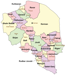
Anbarabad County
Anbarabad County
Persian: شهرستان عنبرآباد | |
|---|---|
 Location of Anbarabad County in Kerman province (center right, purple) | |
 Location of Kerman province in Iran | |
| Coordinates: 28°28′N 57°58′E / 28.467°N 57.967°E[1] | |
| Country | Iran |
| Province | Kerman |
| Capital | Anbarabad |
| Districts | Central, Jebalbarez-e Jonubi |
| Population (2016)[2] | |
| • Total | 82,438 |
| Time zone | UTC+3:30 (IRST) |
| Anbarabad County can be found at GEOnet Names Server, at this link, by opening the Advanced Search box, entering "9206703" in the "Unique Feature Id" form, and clicking on "Search Database". | |
Anbarabad County (Persian: شهرستان عنبرآباد) is in Kerman province, Iran. Its capital is the city of Anbarabad.
History
[edit]In 2003 Anbarabad was recognized as a county and separated from Jiroft County.[3]
After the 2006 National Census, the village of Dow Sari was elevated to the status of a city. Esmaili District was separated from the county to rejoin Jiroft County.[4]
Demographics
[edit]Language
[edit]Most residents are ethnic Persians and speak that language.[citation needed]
Population
[edit]At the time of the 2006 census, the county's population was 113,751 in 23,858 households.[5] The following census in 2011 counted 85,942 people in 20,947 households.[6] The 2016 census measured the population of the county as 82,438 in 23,409 households.[2]
Administrative divisions
[edit]Anbarabad County's population history and administrative structure over three consecutive censuses are shown in the following table.
| Administrative Divisions | 2006[5] | 2011[6] | 2016[2] |
|---|---|---|---|
| Central District | 52,777 | 57,385 | 58,191 |
| Aliabad RD | 7,968 | 10,312 | 10,635 |
| Amjaz RD | 3,970 | 3,450 | 2,951 |
| Jahadabad RD | 16,891 | 15,106 | 16,258 |
| Mohammadabad RD | 5,358 | 6,024 | 6,032 |
| Anbarabad (city) | 18,590 | 18,731 | 18,185 |
| Dow Sari (city) | 3,762 | 4,130 | |
| Esmaili District[a] | 37,062 | ||
| Esmaili RD | 11,745 | ||
| Ganjabad RD | 9,427 | ||
| Hoseynabad RD | 15,890 | ||
| Jebalbarez-e Jonubi District | 23,912 | 28,557 | 24,247 |
| Garmsar RD | 7,668 | 7,822 | 7,613 |
| Mardehek RD | 7,785 | 10,820 | 8,112 |
| Nargesan RD | 6,547 | 7,011 | 5,652 |
| Mardehek (city) | 1,912 | 2,904 | 2,870 |
| Total | 113,751 | 85,942 | 82,438 |
| RD = Rural District | |||
See also
[edit]![]() Media related to Anbarabad County at Wikimedia Commons
Media related to Anbarabad County at Wikimedia Commons
Notes
[edit]- ^ Transferred to Jiroft County[4]
References
[edit]- ^ OpenStreetMap contributors (24 June 2023). "Anbarabad County" (Map). OpenStreetMap (in Persian). Retrieved 24 June 2023.
- ^ a b c "Census of the Islamic Republic of Iran, 1395 (2016)". AMAR (in Persian). The Statistical Center of Iran. p. 08. Archived from the original (Excel) on 20 October 2020. Retrieved 19 December 2022.
- ^ Aref, Mohammad Reza (18 December 1381). "Approval of divisional changes and reforms in Kerman province". Lamtakam (in Persian). Ministry of Interior, Political-Defense Commission of the Government Board. Archived from the original on 3 February 2024. Retrieved 3 February 2024.
- ^ a b Rahimi, Mohammad Reza (28 September 1389). "Approval letter regarding the annexation of the Esmaili District centered on Boluk village from Anbarabad County in Kerman province to Jiroft County". Lamtakam (in Persian). Ministry of Interior, Political and Defense Commission. Archived from the original on 2 February 2024. Retrieved 2 February 2024.
- ^ a b "Census of the Islamic Republic of Iran, 1385 (2006)". AMAR (in Persian). The Statistical Center of Iran. p. 08. Archived from the original (Excel) on 20 September 2011. Retrieved 25 September 2022.
- ^ a b "Census of the Islamic Republic of Iran, 1390 (2011)". Syracuse University (in Persian). The Statistical Center of Iran. p. 08. Archived from the original (Excel) on 29 March 2023. Retrieved 19 December 2022.

