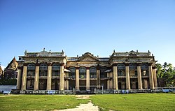
Puthia Upazila
Puthia
পুঠিয়া | |
|---|---|
 | |
 | |
| Coordinates: 24°22.5′N 88°51′E / 24.3750°N 88.850°E | |
| Country | |
| Division | Rajshahi |
| District | Rajshahi |
| Area | |
| • Total | 192.63 km2 (74.37 sq mi) |
| Population | |
| • Total | 224,143 |
| • Density | 1,200/km2 (3,000/sq mi) |
| Time zone | UTC+6 (BST) |
| Postal code | 6260[2] |
| Area code | 07228[3] |
| Website | Official Map of Puthia |
Puthia (Bengali: পুঠিয়া) is an Upazila of Rajshahi District in the Division of Rajshahi, Bangladesh.[4]
Geography
[edit]Puthia is located at 24°22′30″N 88°51′00″E / 24.3750°N 88.8500°E. It has 52,922 households and total area 192.63 km2. This is a historical & traditional place in Bangladesh for Puthia Rajbari & Shiva Temple Complex.
Demographics
[edit]According to the 2011 Census of Bangladesh, Puthia Upazila had 52,922 households and a population of 207,490. 37,278 (17.97%) were under 10 years of age. Puthia had a literacy rate (age 7 and over) of 49.58%, compared to the national average of 51.8%, and a sex ratio of 975 females per 1000 males. 25,761 (12.42%) lived in urban areas.[6] Ethnic population was 1,698 (0.82%).[7]
As of the 1991 Bangladesh census, Puthia has a population of 342,405. Males constitute 51.16% of the population, and females 48.84%. This Upazila's eighteen up population is 81679. Puthia has an average literacy rate of 25.5% (7+ years), and the national average of 32.4% literate.[8]
Administration
[edit]Puthia Upazila is divided into Puthia Municipality and six union parishads: Baneshwar, Belpukuria, Bhalukgachhi, Jeopara, Puthia, and Silmaria. The union parishads are subdivided into 128 mauzas and 183 villages.[6]
Education
[edit]

There are 12 colleges in the upazila. They include Dhokrakul Degree College, Dhopapara Memorial Degree College, Ideal Degree College, Laskherpur Degree Mahavidya Niketan, Pangu Shishu Niketon S A Degree College, Pochamaria Degree College, Puthia Islamia Mohila College, and Puthia Mohila Degree College. Baneshwar College, founded in 1964, is the only honors level one.[4][9]
According to Banglapedia, Dhokrakul High School, founded in 1949, and PN Technical High School (1865), are notable secondary schools.[4]
See also
[edit]- Upazilas of Bangladesh
- Districts of Bangladesh
- Divisions of Bangladesh
- Puthia Temple Complex
- Puthia Rajbari (palace)
- Pancha Ratna Govinda Temple
References
[edit]- ^ National Report (PDF). Population and Housing Census 2022. Vol. 1. Dhaka: Bangladesh Bureau of Statistics. November 2023. p. 402. ISBN 978-9844752016.
- ^ "Bangladesh Postal Code". Dhaka: Bangladesh Postal Department under the Department of Posts and Telecommunications of the Ministry of Posts, Telecommunications and Information Technology of the People's Republic of Bangladesh. 21 October 2024.
- ^ "Bangladesh Area Code". China: Chahaoba.com. 18 October 2024.
- ^ a b c AKM Kaisaruzzaman (2012), "Puthia Upazila", in Sirajul Islam and Ahmed A. Jamal (ed.), Banglapedia: National Encyclopedia of Bangladesh (Second ed.), Asiatic Society of Bangladesh
- ^ Population and Housing Census 2022 - District Report: Rajshahi (PDF). District Series. Dhaka: Bangladesh Bureau of Statistics. June 2024. ISBN 978-984-475-230-6.
- ^ a b "Bangladesh Population and Housing Census 2011 Zila Report – Rajshahi" (PDF). bbs.gov.bd. Bangladesh Bureau of Statistics.
- ^ "Community Tables: Rajshahi district" (PDF). bbs.gov.bd. Bangladesh Bureau of Statistics. 2011.
- ^ "Population Census Wing, BBS". Archived from the original on 2005-03-27. Retrieved November 10, 2006.
- ^ "List of Colleges" (Excel). Bangladesh Bureau of Education Information and Statistics.
External links
[edit]- Official website (in Bengali)

