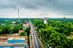
Joypurhat Sadar Upazila
Joypurhat Sadar
জয়পুরহাট সদর | |
|---|---|
 View of Joypurhat | |
 | |
| Coordinates: 25°06′N 89°02′E / 25.100°N 89.033°E | |
| Country | |
| Division | Rajshahi |
| District | Joypurhat |
| Area | |
• Total | 236.79 km2 (91.43 sq mi) |
| Population | |
• Total | 315,205 |
| • Density | 1,300/km2 (3,400/sq mi) |
| Time zone | UTC+6 (BST) |
| Postal code | 5900[2] |
| Area code | 0571[3] |
| Website | joypurhatsadar |
Joypurhat Sadar (Bengali: জয়পুরহাট সদর) is an upazila of Joypurhat District in the Division of Rajshahi, Bangladesh.[4]
Geography
[edit]Joypurhat Sadar is located at 25°06′N 89°02′E / 25.100°N 89.033°E. It has 76,385 households and total area 238.54 km2.
Joypurhat Sadar Upazila is bounded by Panchbibi Upazila and Balurghat CD Block in Dakshin Dinajpur district, West Bengal, India, on the north, Kalai and Khetlal Upazilas on the east, Khetlal, Akkelpur and Badalgachhi Upazilas on the south and Dhamoirhat Upazila and Balurghat CD Block on the west.[5][6][7]
Demographics
[edit]According to the 2011 Census of Bangladesh, Joypurhat Sadar Upazila had 76,385 households and a population of 289,058. 51,683 (17.88%) were under 10 years of age. Joypurhat Sadar had a literacy rate (age 7 and over) of 65.37%, compared to the national average of 51.8%, and a sex ratio of 965 females per 1000 males. 69,033 (23.88%) lived in urban areas.[9] Ethnic population was 8,174 (2.83%), of which Oraon were 1,493 and Barman 1,121.[10]
As of the 1991 Bangladesh census, Joypurhat Sadar has a population of 225271. Males constitute 52.18% of the population, and females 47.82%. This Upazila's eighteen up population is 123804. Joypurhat Sadar has an average literacy rate of 33.1% (7+ years), and the national average of 32.4% literate.[11]
Points of interest
[edit]Joypurhat Sugar Mill's Limited is the largest autonomous sugar mill in the country. Pagla Dewan Boddhovumi is one of Bangladesh's most important monuments In the Belamla Village there are both the historical "Barashibalaya Temple" and "Akshibalaya Temple", famous historical places. Shahid doctor Abul Kasem Maidan is the main feature of this upazila. The central shahid minar of Joypurahat district is also situated here.

Administration
[edit]Joypurhat Thana was formed in 1918 and it was turned into an upazila in 1984.[12]
Joypurhat Sadar Upazila is divided into Joypurhat Municipality and nine union parishads: Amdai, Bambu, Bhadsha, Chakborket, Dhalahar, Dogachi, Jamalpur, Mohammadabad, and Puranapail. The union parishads are subdivided into 184 mauzas and 192 villages.[9]
Joypurhat Municipality is subdivided into 9 wards and 48 mahallas.[9]
Education
[edit]Joypurhat Girl's Cadet College is the second girl's cadet college of Bangladesh.
Joypurhat Government College is the highest educational institute in the district. The college is situated near the Joypurhat rail station which was established in 1963.
Joypurhat R.B. Govt. High School is the highest level school in the district. The high school was established in 1946 by Ramdeo Bajla. The school is located on the main road. The informal name of this school is "Bazla school" or 'zila school' . This school gained national recognition in 1977.
Joypurhat Govt. Girl's High School is one of the famous schools in the district. It was established in 1960 and nationalized in the year of 1977. The school boasts a 100% passing rate in both Junior and Secondary School Certificate examinations. Business Management Institute: It is first technology institution.
Notable residents
[edit]- Montazur Rahman Akbar, film director, attended Akklepur F. U. Pilot High School.[13]
- Fatema Tuz Zohra, Nazrul Geeti singer, grew up in Joypurhat and attended Joypurhat Government Girls High School.[14][15]
See also
[edit]References
[edit]- ^ National Report (PDF). Population and Housing Census 2022. Vol. 1. Dhaka: Bangladesh Bureau of Statistics. November 2023. p. 401. ISBN 978-9844752016.
- ^ "Bangladesh Postal Code". Dhaka: Bangladesh Postal Department under the Department of Posts and Telecommunications of the Ministry of Posts, Telecommunications and Information Technology of the People's Republic of Bangladesh. 21 October 2024.
- ^ "Bangladesh Area Code". China: Chahaoba.com. 18 October 2024.
- ^ Shahnaz Parveen (2012), "Joypurhat Sadar Upazila", in Sirajul Islam and Ahmed A. Jamal (ed.), Banglapedia: National Encyclopedia of Bangladesh (Second ed.), Asiatic Society of Bangladesh
- ^ "Joypurhat Sadar Upazila". Banglapedia. Retrieved 8 December 2018.
- ^ "District Census Handbook 2011 Dakshin Dinajpur" (PDF). Map of Dakshin Dinajpur showing CD Blocks on the fourth page. Directorate of Census Operations. Retrieved 8 December 2018.
- ^ "District Human Development Report". Uttar Dinajpur. Page 14: Map showing locational setting of Uttar Dinajpur district (includes Dakshin Dinajpur district). Department of Planning, Statistics and Programme Implementation, Government of West Bengal. Retrieved 8 December 2018.
- ^ Population and Housing Census 2022 - District Report: Joypurhat (PDF). District Series. Dhaka: Bangladesh Bureau of Statistics. June 2024. ISBN 978-984-475-234-4.
- ^ a b c "Bangladesh Population and Housing Census 2011 Zila Report – Joypurhat" (PDF). bbs.gov.bd. Bangladesh Bureau of Statistics.
- ^ "Community Tables: Joypurhat district" (PDF). bbs.gov.bd. Bangladesh Bureau of Statistics. 2011.
- ^ "Population Census Wing, BBS". Archived from the original on 2005-03-27. Retrieved November 10, 2006.
- ^ "Joypurhat Sadar Upazila - Banglapedia". en.banglapedia.org. Retrieved 2023-02-22.
- ^ একজন যোদ্ধার গল্প [A warrior's story]. Ittefaq. 6 April 2017.
- ^ Rahman, Musfequr (23 September 2011). "Devoted Nazrul singer Fatema Tuz Zohra". Holiday. Archived from the original on 4 February 2018. Retrieved 9 February 2020.
- ^ Saha, Jyot (12 October 2014). সিনেমায় ফাতেমা তুজ জোহরা [Fatema Tuz Johra in the movie]. bdnews24.com (in Bengali).

