Portal:Romania/Geography
| Main Page | Geography | Topics |
Romania Portal

|

|

| |
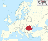
Romania (dated: Rumania, Roumania; Romanian: România, [ro.mɨˈni.a]) is a country located at the crossroads of Central and Southeastern Europe. It shares a border with Hungary to the north-west, Serbia to the south-west, Ukraine to the north and a small portion in the central-east border, Republic of Moldova to the north-east, and Bulgaria to the south. Romania has a stretch of sea coast along the Black Sea in the south-east. It is located roughly in the lower basin of the Danube and almost all of the Danube Delta is located within its territory.
Romania is a semi-presidential unitary state. As a nation-state, the country was formed by the merging of Moldavia and Wallachia in 1859 and it gained recognition of its independence in 1878. Later, in 1918, they were joined by Transylvania, Bukovina and Bessarabia. At the end of World War II, parts of its territories (roughly the present day Moldova) were occupied by USSR and Romania became a member of Warsaw Pact. With the fall of the Iron Curtain in 1989, Romania started a series of political and economic reforms that enabled Romania to join the European Union on 1 January 2007.
Administrative divisions
Other Wikimedia and Wikiportals
The following Wikimedia Foundation sister projects provide more on this subject:
-
Commons
Free media repository -
Wikibooks
Free textbooks and manuals -
Wikidata
Free knowledge base -
Wikinews
Free-content news -
Wikiquote
Collection of quotations -
Wikisource
Free-content library -
Wikispecies
Directory of species -
Wikiversity
Free learning tools -
Wikivoyage
Free travel guide -
Wiktionary
Dictionary and thesaurus
Parent portals: Europe | European Union


