Podolí (Prague)
Appearance
Podolí | |
|---|---|
Cadastral Area of Prague | |
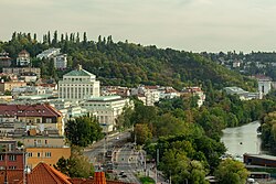
 View of Podolí, Podolí Waterworks in the background | |
 Location of Podolí in Prague | |
| Coordinates: 50°03′11″N 14°25′24″E / 50.05306°N 14.42333°E | |
| Country | Czech Republic |
| Region | Prague |
| District | Prague 4 |
| Area | |
| • Total | 2.38 km2 (0.92 sq mi) |
| Population (2021)[1] | |
| • Total | 13,611 |
| • Density | 5,700/km2 (15,000/sq mi) |
| Time zone | UTC+1 (CET) |
| • Summer (DST) | UTC+2 (CEST) |
Podolí is a district in Prague located south of the city centre, on the right (east) riverbank. It borders Vyšehrad in the north, Pankrác (a part of Nusle and Krč districts) in the east and Braník in the south. The river Vltava separates Podolí from Smíchov and Hlubočepy on the other riverbank.
Notable buildings of the district include the neoclassical Podolí Waterworks completed in the 20th century, Church of St. Michael the Archangel which is one of the oldest churches in the whole city or Podolí Swimming Stadium.
Demographics
[edit]Wikimedia Commons has media related to Podolí (Prague).
|
|
| ||||||||||||||||||||||||||||||||||||||||||||||||||||||
| Source: Censuses[2][1] | ||||||||||||||||||||||||||||||||||||||||||||||||||||||||
References
[edit]- ^ a b "Results of the 2021 Census - Open data". Public Database (in Czech). Czech Statistical Office. 2021-03-27.
- ^ "Historický lexikon obcí České republiky 1869–2011 – Praha" (PDF) (in Czech). Czech Statistical Office. 2015-12-21.
