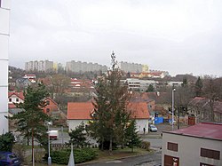
Hostivař
Appearance
Hostivař | |
|---|---|
 | |
| Coordinates: 50°03′10″N 14°31′50″E / 50.05278°N 14.53056°E | |
| Country | |
| Administrative district | Prague 10 |
| Municipal part | Prague 15 |
| Area | |
• Total | 8.00 km2 (3.09 sq mi) |
| Population (2021)[1] | |
• Total | 19,161 |
| • Density | 2,400/km2 (6,200/sq mi) |
Hostivař (German: Hostiwar) is a cadastral area in southern Prague.
Demographics
[edit]
|
|
| ||||||||||||||||||||||||||||||||||||||||||||||||||||||
| Source: Censuses[2][1] | ||||||||||||||||||||||||||||||||||||||||||||||||||||||||
References
[edit]- ^ a b "Results of the 2021 Census - Open data". Public Database (in Czech). Czech Statistical Office. 2021-03-27.
- ^ "Historický lexikon obcí České republiky 1869–2011 – Praha" (in Czech). Czech Statistical Office. 2015-12-21.
External links
[edit] Media related to Hostivař at Wikimedia Commons

